The following list of parks and preserves includes those managed by federal, state, county, and non-governmental agencies (such as the National Audubon Society, the Nature Conservancy, various historical societies, etc.).
We have tried to collect information on the activities and facilities available at various parks, but things may change without us knowing about it. So please double-check the information at the official site.
- Alley Park (City Park)
-
- Official Site
- Trail Map
- Posts at TrekOhio
- Location:
- 2805 Old Logan Rd, Lancaster, Ohio
- GPS coordinates: 39.68059, -82.5815643
- View on Google Maps
- 300 acres in all
- 6 miles of total trail
- Supported activities:
- Fishing
- Bringing your dog
- Facilities:
- Restroom facilities
- Handicap accessible
- Nature center
- Miscellaneous info: Camp sites under development
- Blacklick Creek Bike Trail (Bike Path)
-
- Official Site
- Trail Map
- 12 miles of paved, multi-use trail
- Supported activities:
- Bringing your dog
- Facilities:
- Restroom facilities
- Handicap accessible
- Miscellaneous info: There are trailheads to the Blacklick Creek Greenway Trail in Three Creeks Park, Portman Park, Pickerington Ponds Metro Park, and Blacklick Woods Metro Park.
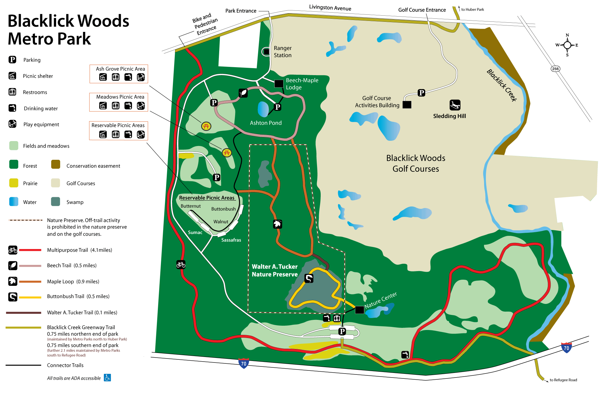
- Blacklick Woods (Metro Park)
-
- Official Site
- Trail Map
- Trail descriptions
- Posts at TrekOhio
- Location:
- 6975 E. Livingston Ave., Reynoldsburg, Ohio 43068
- GPS coordinates: 39.943795, -82.8138957
- View on Google Maps
- 643 acres in all
- 7.5 miles of total trail
- Supported activities:
- Cross-country skiing
- Sledding
- Good site for bird watching
- Facilities:
- Restroom facilities
- Nature center
- Golf course
- Miscellaneous info: This metropark serves as one of the trailheads for the Blacklick Creek Greenway.
- Buckeye Lake (State Park)
-
- Official Site
- Hunting Map
- Park Map
- Location:
- 2905 Liebs Island Road, Millersport, Ohio 43046
- GPS coordinates: 39.9047361, -82.5307596
- View on Google Maps
- 3,100 acres lake
- Supported activities:
- Fishing
- Hunting
- Cross-country skiing
- Bringing your dog
- Paddling
- Boating with high horsepower motors
- Ice skating
- Facilities:
- Restroom facilities
- Miscellaneous info: While construction is underway at the dam, the park’s beaches are closed.
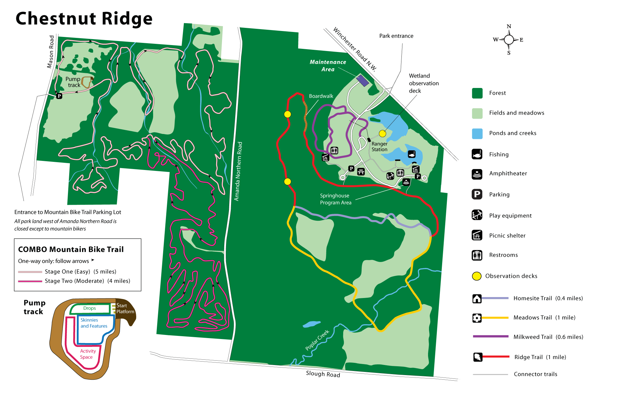
- Chestnut Ridge (Metro Park)
-
- Official Site
- Trail Map
- Trail descriptions
- Posts at TrekOhio
- Location:
- 8445 Winchester Road N.W., Carroll, Ohio 43112
- GPS coordinates: 39.8104575, -82.7567171
- View on Google Maps
- 486 acres in all
- 2.4 miles of total trail
- Supported activities:
- Fishing
- Mountain biking
- Cross-country skiing
- Good site for bird watching
- Bringing your dog
- Facilities:
- Restroom facilities
- Handicap accessible
- Christmas Rocks State Nature Preserve (State Nature Preserve)
-
- Official Site
- Posts at TrekOhio
- Location:
- 2340 Meister Rd SW, Lancaster, Ohio 43130 (estimated using Google Maps)
- GPS coordinates: 39.639748, -82.650034
- View on Google Maps
- 554 acres in all
- 4.75 miles of total trail
- Prohibited activities:
- Dogs not permitted
- Facilities:
- No restroom facilities
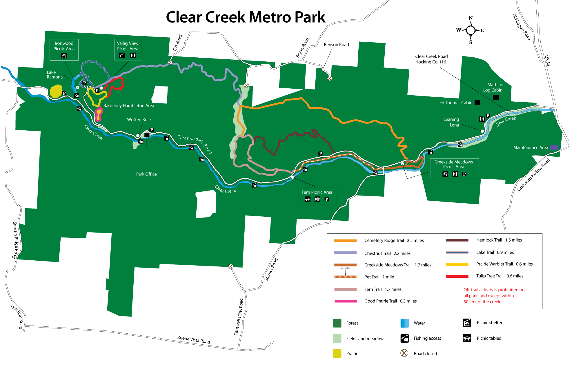
- Clear Creek (Metro Park)
-
- Official Site
- Trail Map
- Trail descriptions
- Posts at TrekOhio
- Location:
- 185 Clear Creek Road, Rockbridge, Ohio 43149
- GPS coordinates: 39.5939241, -82.6237622
- View on Google Maps
- 5,260 acres in all
- 14 miles of total trail
- Supported activities:
- Fishing
- Good site for bird watching
- Bringing your dog
- Facilities:
- Restroom facilities
- Miscellaneous info: Includes 4,769 acre Clear Creek (Allen F. Beck) State Nature Preserve
- Cross Mound (County Park)
-
- Official Site
- Location:
- 11615 Sixteenth Road, Stoutsville, Ohio 43154
- GPS coordinates: 39.5629873, -82.7831294
- View on Google Maps
- 29 acres in all
- 1 miles of total trail
- Miscellaneous info: Prehistoric X-shaped mound, possibly constructed by the Fort Ancient Native Americans. To access it you cross a suspension foot-bridge that was built by the Works Progress Administration during the Great Depression (1936).
- Fairfield Heritage Trail (Bike Path)
-
- Official Site
- Trail Map
- Trail information:
- 9.5 miles of total trail
- 8 miles of paved path
- Johns Trail (Amanda, OH) (Bike Path)
-
- Official Site
- Trail Map
- 1.6 miles of total trail
- Miscellaneous info: Gravel trail
- Lockville Park (County Park)
-
- Official Site
- Posts at TrekOhio
- Location:
- 5895 Pickerington Road NW, Carroll, Ohio 43112
- GPS coordinates: 39.817526, -82.738506
- View on Google Maps
- 6 acres in all
- Miscellaneous info: Three intact locks that were once part of the Ohio Erie canal; there is also a covered bridge on the premises.
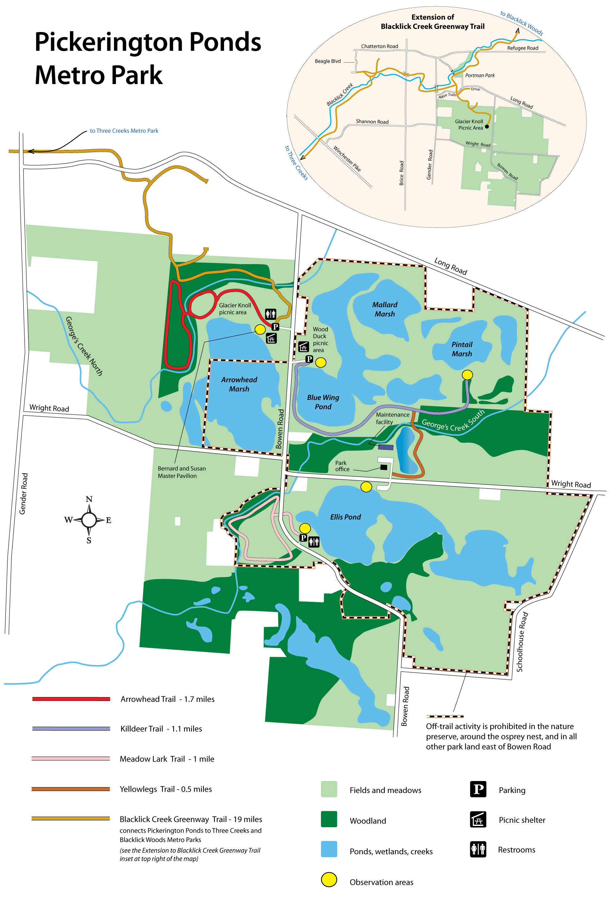
- Pickerington Ponds (Metro Park)
-
- Official Site
- Park Map
- Trail descriptions
- Posts at TrekOhio
- Location:
- 7680 Wright Road, Canal Winchester, Ohio 43110
- GPS coordinates: 39.8860621, -82.8030397
- View on Google Maps
- 1,608 acre in all
- 5.1 miles of total trail
- Supported activities:
- Good site for bird watching
- Facilities:
- Restroom facilities
- Handicap accessible
- Rhododendron Cove (State Nature Preserve)
-
- Official Site
- Posts at TrekOhio
- Location:
- Pump Station Rd SE, Berne Township, Ohio
- GPS coordinates: 39.631637, -82.558093
- View on Google Maps
- 75 acres in all
- 2.25 miles of total trail
- Prohibited activities:
- Dogs not permitted
- Facilities:
- No restroom facilities
- Rising Park (City Park)
-
- Official Site
- Posts at TrekOhio
- Location:
- 1100 N High St, Lancaster, Ohio 43130
- GPS coordinates: 39.726251, -82.593395
- View on Google Maps
- 73 acres in all
- Supported activities:
- Fishing
- Bringing your dog
- Facilities:
- Restroom facilities
- Miscellaneous info: Hiking trail to sandstone bluff overlooking Lancaster
- Rock Mill (County Park)
-
- Official Site
- Posts at TrekOhio
- Covered Bridge
- Location:
- 1429 Rock Mill Place NW, Lancaster, Ohio 43112
- GPS coordinates: 39.749184, -82.713352
- View on Google Maps
- Miscellaneous info: This large grist mill has been restored to the point that it can once again grind grain. It is located on the upper falls of Hocking River. Rock Mill covered bridge is nearby.
- Shallenberger (State Nature Preserve)
-
- Official Site
- Posts at TrekOhio
- Location:
- 2468 Becks Knob Road SW, Lancaster, Ohio 43130
- GPS coordinates: 39.6913412, -82.6560494
- View on Google Maps
- 88 acres in all
- About 2.5 miles of hiking trail
- Prohibited activities:
- Dogs not permitted
- Facilities:
- No restroom facilities
- Wahkeena (Ohio Historical Society)
-
- Official Site
- Alternative Official Site
- Calendar of Events
- Posts at TrekOhio
- Location:
- 2200 Pump Station Rd SE, Berne, Ohio 43155
- GPS coordinates: 39.6289625, -82.5686296
- View on Google Maps
- 150 acres in all
- About 2 miles of hiking trail
- Supported activities:
- Good site for bird watching
- Prohibited activities:
- Dogs not permitted
- Facilities:
- Restroom facilities
- Nature center
- Walter Tucker (State Nature Preserve)
-
- Official Site
- 55 acres in all
- Miscellaneous info: The preserve is within the boundaries of the Blacklick Woods Metro Park.
Last Update: Jun 22, 2018
© Deborah Platt, Robert Platt and TrekOhio.com 2012 to 2021