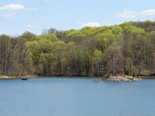
 A.W. Marion State Park is a 309-acre park with a 145-acre lake within its borders. The lake, known as Hargus Lake, has been stocked with largemouth bass, muskellunge, bluegill and channel catfish. Currently the Ohio Dept. of Natural Resources (ODNR) only permits boats to use electric motors. Although the lake doesn't have a beach, boaters are allowed to swim from their boats in one corner of the lake (the swimming area is marked on the park's map).
I visited the park twice in late April of last Read more ➜
A.W. Marion State Park is a 309-acre park with a 145-acre lake within its borders. The lake, known as Hargus Lake, has been stocked with largemouth bass, muskellunge, bluegill and channel catfish. Currently the Ohio Dept. of Natural Resources (ODNR) only permits boats to use electric motors. Although the lake doesn't have a beach, boaters are allowed to swim from their boats in one corner of the lake (the swimming area is marked on the park's map).
I visited the park twice in late April of last Read more ➜ A.W. Marion State Park
A.W. Marion State Park is a 309-acre park with a 145-acre lake within its borders. The lake, known as Hargus Lake, has been stocked with largemouth bass, muskellunge, bluegill and channel catfish. Currently the Ohio Dept. of Natural Resources (ODNR) only permits boats to use electric motors. Although the lake doesn't have a beach, boaters are allowed to swim from their boats in one corner of the lake (the swimming area is marked on the park's map).
I visited the park twice in late April of last Read more ➜ 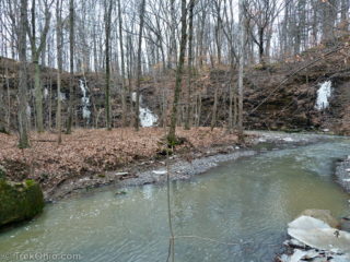 Shale Hollow is Delaware County's newest park having just opened in December. It is named for a small canyon of 20 to 40 foot shale cliffs rising above a stream named Big Run.
We visited Shale Hollow a couple of times in the past month. The park consists of 188 acres encompassing a ravine, forest, and meadowland. A gravel roadway leads to a parking area next to a nature center. The nature center features a small exhibit explaining the natural history of the area including the 375 million
Shale Hollow is Delaware County's newest park having just opened in December. It is named for a small canyon of 20 to 40 foot shale cliffs rising above a stream named Big Run.
We visited Shale Hollow a couple of times in the past month. The park consists of 188 acres encompassing a ravine, forest, and meadowland. A gravel roadway leads to a parking area next to a nature center. The nature center features a small exhibit explaining the natural history of the area including the 375 million 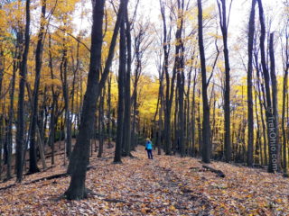 The weekend before last Bob and I paid a visit to Great Seal State Park in Ross County, Ohio. This 1862-acre park features 5 miles of nature trail plus an additional 17 miles of multi-use trails that may be used for hiking, mountain biking and horseback riding. The central feature of the park is a line of hills that are depicted on the Great Seal of Ohio.
The Great Seal Of Ohio
Just like the United States has a great seal (pictured here), all of the individual states have their
The weekend before last Bob and I paid a visit to Great Seal State Park in Ross County, Ohio. This 1862-acre park features 5 miles of nature trail plus an additional 17 miles of multi-use trails that may be used for hiking, mountain biking and horseback riding. The central feature of the park is a line of hills that are depicted on the Great Seal of Ohio.
The Great Seal Of Ohio
Just like the United States has a great seal (pictured here), all of the individual states have their 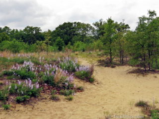 Oak Openings Metro Park is a 4,000 acre metro park in Lucas county. It has over 30 miles of well-marked hiking trails over some of the state's most interesting and diverse terrain. It features many varieties of plants, and it is on the main path for seasonal bird migration. Oak openings also has sand dunes despite being miles from the nearest large body of water. How the sand dunes got there is an interesting story in itself.
The History and Habitat
Twenty one thousand years ago,
Oak Openings Metro Park is a 4,000 acre metro park in Lucas county. It has over 30 miles of well-marked hiking trails over some of the state's most interesting and diverse terrain. It features many varieties of plants, and it is on the main path for seasonal bird migration. Oak openings also has sand dunes despite being miles from the nearest large body of water. How the sand dunes got there is an interesting story in itself.
The History and Habitat
Twenty one thousand years ago,  Thayer Ridge Park features a picnic area (without restrooms), a frisbee disc golf course, and some multi-use, dirt trails going through woodland and meadows. The trails are open to horseback riders, mountain bikers and hikers. I have hiked there twice (in April and in August); in my opinion the trails are probably best suited for those on horseback.
On each of my two visits it was clear that the trails were being used regularly by riders. Here's why I think the trail conditions are
Thayer Ridge Park features a picnic area (without restrooms), a frisbee disc golf course, and some multi-use, dirt trails going through woodland and meadows. The trails are open to horseback riders, mountain bikers and hikers. I have hiked there twice (in April and in August); in my opinion the trails are probably best suited for those on horseback.
On each of my two visits it was clear that the trails were being used regularly by riders. Here's why I think the trail conditions are 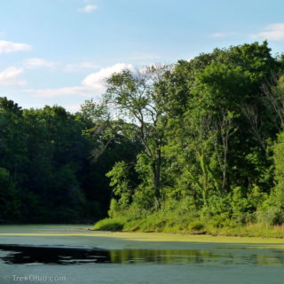 Char-Mar Ridge is part of Delaware County's preservation park system. It features a wooded trail that passes over gently rolling hills. The trail itself is packed earth and gravel that remains in good condition even when it's rainy. A 0.25 mile trail connects the parking lot to a loop trail. The loop trail is 1.5 miles and is very popular with joggers who often do multiple laps. Like most of Delaware County's parks, visitors are allowed to bring their leashed dogs along with them. "Mutt mitts" are
 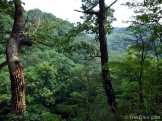 The Earl H Barnhart "Buzzards Roost" Nature Preserve is a large (1330 acres) preserve run by Ross County Park district. We visited in the early afternoon on a hot sunny day in late May. The preserve is on a plateau that ends in a cliff overlooking the Paint Creek valley.
There's so little information about this nature preserve online that we are including more than the usual number of photos to give prospective hikers a better idea of what it's like.
There are two trails at
The Earl H Barnhart "Buzzards Roost" Nature Preserve is a large (1330 acres) preserve run by Ross County Park district. We visited in the early afternoon on a hot sunny day in late May. The preserve is on a plateau that ends in a cliff overlooking the Paint Creek valley.
There's so little information about this nature preserve online that we are including more than the usual number of photos to give prospective hikers a better idea of what it's like.
There are two trails at 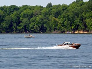 We only sampled a small part of the offerings at Caesar Creek State Park, but we liked what we saw! Caesar Creek caters to a diverse variety of interests. Whether you want to hike, camp, swim, fish, mountain bike, ride on a bridle trail, go boating, or even hunt fossils, Caesar Creek has it all.
The park is located just off I-71 between Columbus and Cleveland in Warren County. We visited the park after hiking at nearby Caesar Creek Gorge Nature Preserve.
The main feature of the
We only sampled a small part of the offerings at Caesar Creek State Park, but we liked what we saw! Caesar Creek caters to a diverse variety of interests. Whether you want to hike, camp, swim, fish, mountain bike, ride on a bridle trail, go boating, or even hunt fossils, Caesar Creek has it all.
The park is located just off I-71 between Columbus and Cleveland in Warren County. We visited the park after hiking at nearby Caesar Creek Gorge Nature Preserve.
The main feature of the 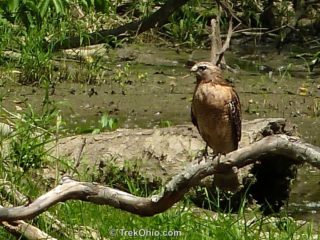 The Emily Traphagen Preserve is part of Delaware County's Preservation Park system. There are two short trails in the park:
White Tail Loop (0.6 miles), and
Meadow Trail (0.5 miles)
Both trails are loops. As you might expect, Meadow Trail is a mown path. However the White Tail Loop is an improved dirt trail that passes through the woods and by a marsh area. From White Tail Loop there is a side trail to what's called the Pond Overlook. I spotted the red-shouldered hawk pictured
The Emily Traphagen Preserve is part of Delaware County's Preservation Park system. There are two short trails in the park:
White Tail Loop (0.6 miles), and
Meadow Trail (0.5 miles)
Both trails are loops. As you might expect, Meadow Trail is a mown path. However the White Tail Loop is an improved dirt trail that passes through the woods and by a marsh area. From White Tail Loop there is a side trail to what's called the Pond Overlook. I spotted the red-shouldered hawk pictured 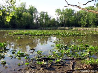 Boyer Nature Preserve is wonderful, mini-wetland that sits in the middle of suburban Westerville, Ohio. The site's main feature is its stream-fed pond. Although it may look like an ordinary pond, it's actually very special due to the way that it was formed. During the last ice age, Westerville was beneath approximately one thousand feet of ice (305 m). As the climate warmed, a large fracture formed near the edge of the melting glacier. Once that fracture became large enough, a huge slab of ice separated