The following list of parks and preserves includes those managed by federal, state, county, and non-governmental agencies (such as the National Audubon Society, the Nature Conservancy, various historical societies, etc.).
We have tried to collect information on the activities and facilities available at various parks, but things may change without us knowing about it. So please double-check the information at the official site.
- Alum Creek Bike Trail (Bike Path)
-
- Official Site
- Trail Map for Noth Section
- Trail Map for Central Section
- Trail Map for South Section
- Trail information:
- 5.25 miles for the North Section
- 3.75 miles for the Central Section
- 5.75 miles for the South Section
- Supported activities:
- Bringing your dog
- Miscellaneous info: Paved, multi-use trail
- Battelle Darby Creek (Metro Park)
-
- Official Site
- Trail Map
- Trail descriptions
- Posts at TrekOhio
- Main Entrance:
- 1775 Darby Creek Drive, Galloway, Ohio 43119
- GPS coordinates: 39.9001391, -83.2130264
- View on Google Maps
- Sledding Hill Entrance:
- 8465 Alkire Road, Galloway, Ohio 43119
- GPS coordinates: 39.8927205, -83.2180181
- View on Google Maps
- 7,060 acres in all
- 18 miles of total trail
- Supported activities:
- Fishing
- Hunting
- Cross-country skiing
- Sledding
- Bringing your dog
- Paddling
- Ice skating
- Facilities:
- Restroom facilities
- Nature center
- Miscellaneous info: Bison pen, dog swimming area
- Blacklick Creek Bike Trail (Bike Path)
-
- Official Site
- Trail Map
- 12 miles of paved, multi-use trail
- Supported activities:
- Bringing your dog
- Facilities:
- Restroom facilities
- Handicap accessible
- Miscellaneous info: Paved multi-use trail
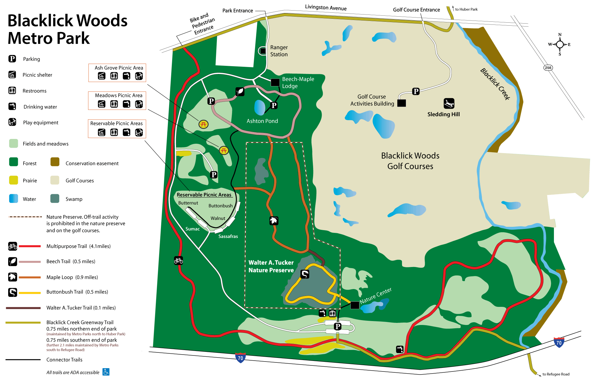
- Blacklick Woods (Metro Park)
-
- Official Site
- Trail Map
- Trail descriptions
- Posts at TrekOhio
- Location:
- 6975 E. Livingston Ave., Reynoldsburg, Ohio 43068
- GPS coordinates: 39.943795, -82.8138957
- View on Google Maps
- 643 acres in all
- 7.5 miles of total trail
- Supported activities:
- Cross-country skiing
- Sledding
- Good site for bird watching
- Facilities:
- Restroom facilities
- Nature center
- Golf course
- Miscellaneous info: This metropark serves as one of the trailheads for the Blacklick Creek Greenway.
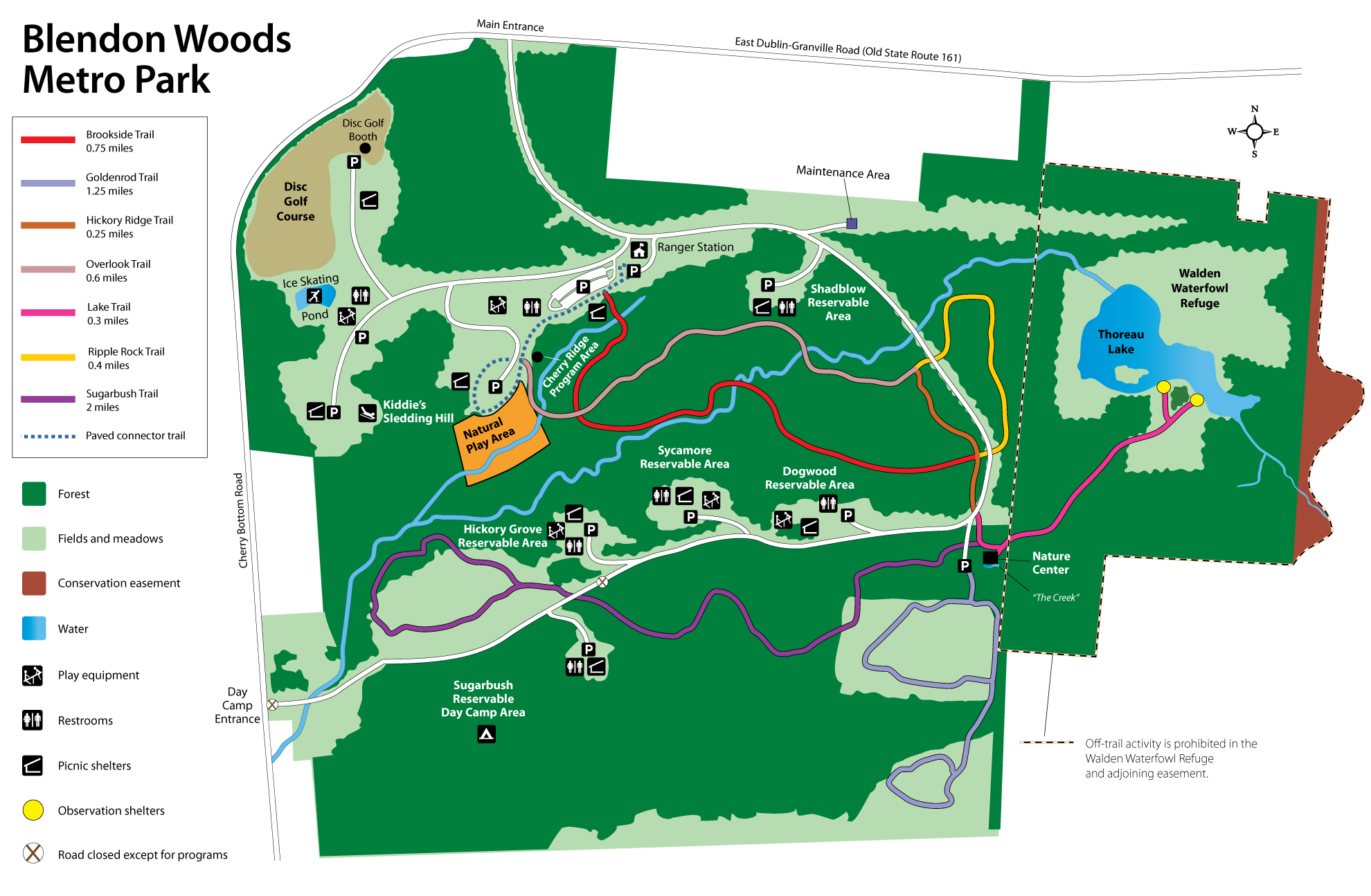
- Blendon Woods (Metro Park)
-
- Official Site
- Trail Map
- Trail descriptions
- Posts at TrekOhio
- Location:
- 4265 E. Dublin-Granville Road, Westerville, Ohio 43081
- GPS coordinates: 40.079902, -82.884679
- View on Google Maps
- Area:
- 653 acres in all
- 118 acres Walden Waterfowl Refuge
- 11 acres Thoreau Lake
- 10 acres Natural Play Area
- 5.5 miles of total trail
- Supported activities:
- Cross-country skiing
- Sledding
- Good site for bird watching
- Bringing your dog
- Ice skating
- Facilities:
- Restroom facilities
- Handicap accessible
- Nature center
- Disc golf course
- Observation deck
- Miscellaneous info: Ice skating pond; pet-walking is limited to the Goldenrod Trail.
- Boyer Nature Preserve (Westerville City Park)
-
- Brochure
- Posts at TrekOhio
- Location:
- 452 E. Park St., Westerville, Ohio 43081
- GPS coordinates: 40.1224325, -82.9178717
- View on Google Maps
- 11 acres in all
- 0.5 miles of total trail
- Supported activities:
- Good site for bird watching
- Bringing your dog
- Miscellaneous info: Kettle pond
- Chadwick Arboretum (Botanical Garden)
-
- Official Site
- Map of the arboretum area
- Location:
- 2001 Fyffe Court, Columbus, Ohio 43210
- GPS coordinates: 40.0041558, -83.0310896
- View on Google Maps
- About 60 acres in all
- Facilities:
- Restroom facilities
- Miscellaneous info: Owned by OSU; admission to the arboretum is free, but you may have to pay to park. There is also free admission to a 12,000 square-foot green roof garden.
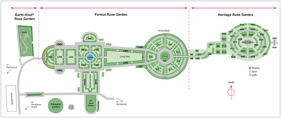
- Columbus Park of Roses (Columbus)
-
- Official Site
- Park Map
- Location:
- 3901 N High St., Columbus, Ohio 43214
- GPS coordinates: 40.043419, -83.026772
- View on Google Maps
- 13 acres in all
- Supported activities:
- Bringing your dog
- Facilities:
- Handicap accessible
- Miscellaneous info: Municipal garden with 11,500 roses in 400 varieties
- Edward Thomas (State Nature Preserve)
-
- Official Site
- 320 acres in all
- Miscellaneous info: The preserve is located withing the boundaries of Sharon Woods Metro Park in Franklin County, Ohio.
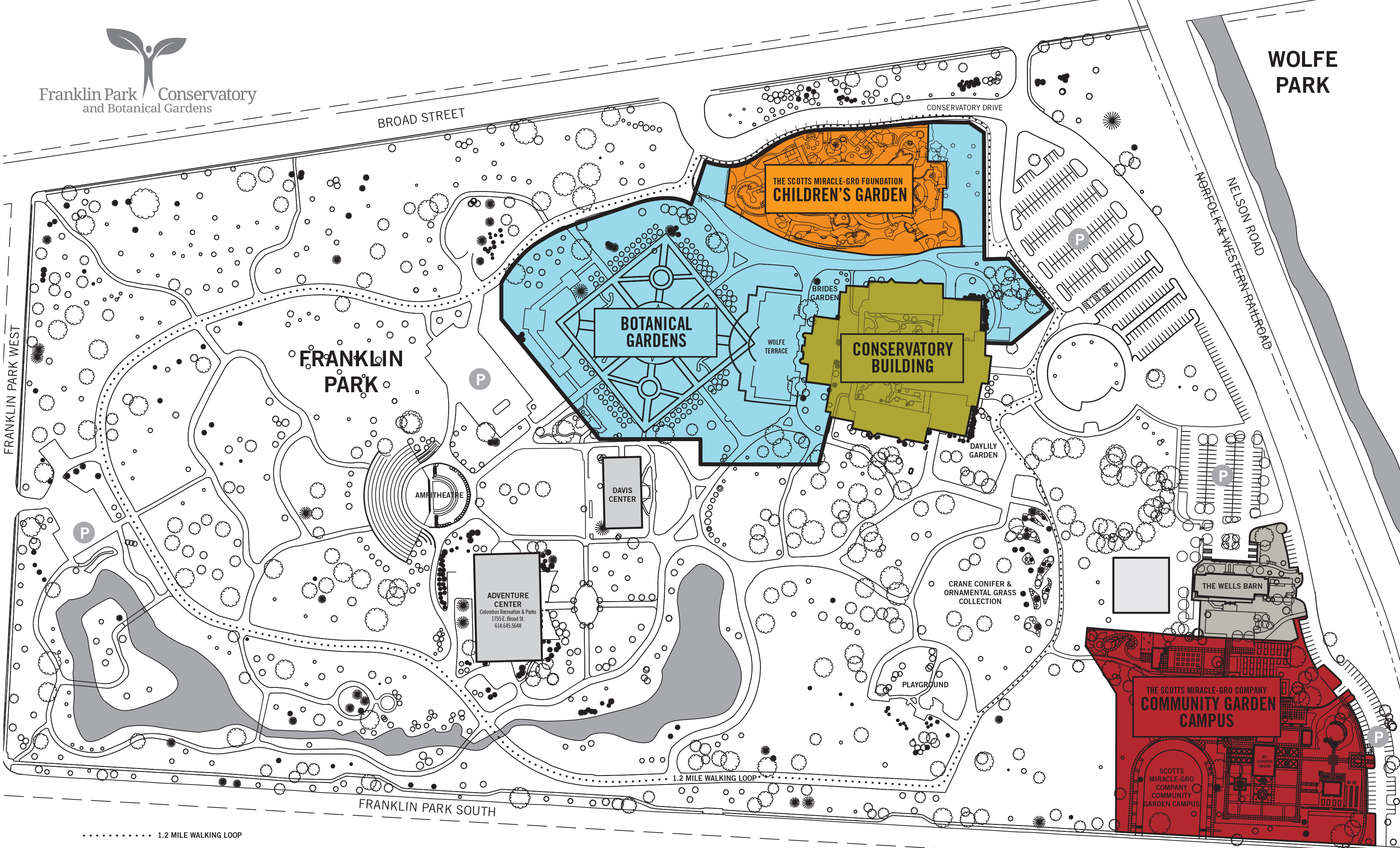
- Franklin Park Conservatory (Botanical Garden)
-
- Official Site
- Park Map
- Location:
- 1777 East Broad St, Columbus, Ohio 43203
- GPS coordinates: 39.965869, -82.9550157
- View on Google Maps
- 90 acres in all
- Facilities:
- Restroom facilities
- Miscellaneous info: Permanent Chihuly glass exhibition in conservatory
- Gahanna Woods (State Nature Preserve)
-
- Official Site
- Alternative Official Site
- Posts at TrekOhio
- Location:
- 1501 Taylor Station Rd, Gahanna, Ohio 43230
- GPS coordinates: 40.011889, -82.834361
- View on Google Maps
- Area:
- 63 acres State Nature Preserve
- 99 acres when the state nature preserve and municipal park are combined
- Miscellaneous info: Buttonbush swamps and vernal pools set within a pin oak-silver maple swamp forest. Nice display of spring wildflowers. Adjacent to a municipal park with the same name.
- Heritage Trail Park (Metro Park (Bike Path))
-
- Official Site
- Trail descriptions
- Map at MyHikes.org
- Location:
- 7262 Hayden Run Road, Hilliard, Ohio 43026
- GPS coordinates: 40.0620499, -83.2030106
- View on Google Maps
- 87 acres in all
- Trail information:
- 6.1 miles of paved, multi-use trail (hiking / cycling / pet walking)
- 3.6 miles of bridle trail
- Supported activities:
- Horseback riding
- Bringing your dog
- Miscellaneous info: Adjacent to the Heritage Rail Trail, a 6.1-mile multi-purpose trail
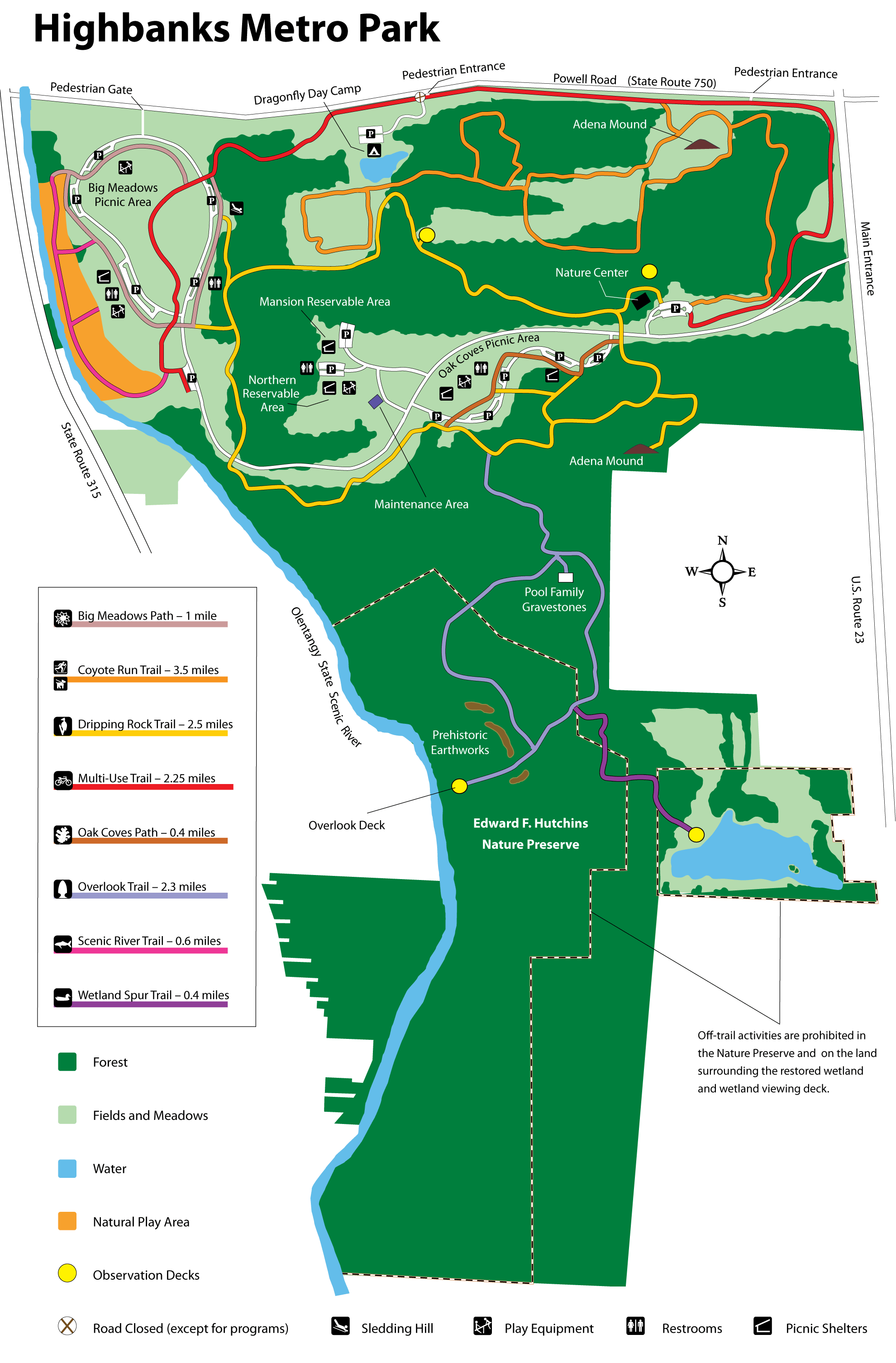
- Highbanks (Metro Park)
-
- Official Site
- Trail Map
- Trail descriptions
- Posts at TrekOhio
- Main Entrance:
- 9466 Columbus Pike (US Rt 23 N), Lewis Center, Ohio 43035
- GPS coordinates: 40.1320893, -83.0062937
- View on Google Maps
- Dragonfly Day Camp:
- 685 W. Powell Road, Lewis Center, Ohio 43065
- GPS coordinates: 40.1559129, -83.0370941
- View on Google Maps
- River Bluff area:
- 8400 Olentangy River Road, Columbus, Ohio 43235
- GPS coordinates: 40.1370306, -83.0392638
- View on Google Maps
- 1,200 acre in all
- Trail information:
- 3.7 miles of paved trails
- 6.1 miles of gravel trails
- 3.9 miles of grass and dirt trails
- Supported activities:
- Fishing
- Cross-country skiing
- Sledding
- Good site for bird watching
- Bringing your dog
- Paddling
- Facilities:
- Restroom facilities
- Handicap accessible
- Nature center
- Miscellaneous info: 15-acre area dedicated to natural play; paddling access to the Olentangy River at the River Bluff area.
- Hoover Reservoir (Columbus City Nature Preserve)
-
- Official Site
- Posts at TrekOhio
- Mud Hen Marsh
- Disc Golf
- Park Area near the Dam:
- 7701 Sunbury Rd., Westerville, Ohio 43081
- GPS coordinates: 40.1080139, -82.8863823
- View on Google Maps
- Brent Hambrick Memorial Disc Golf Course:
- 2000 Central College Rd., Westerville, Ohio 43081
- GPS coordinates: 40.1040154, -82.8859063
- View on Google Maps
- Hoover Mudflats Boardwalk:
- West St. & Front St., Galena, Ohio 43021
- GPS coordinates: 40.213776, -82.88026
- View on Google Maps
- Hoover Meadows:
- Sunbury Road, Galena, Ohio 43021
- GPS coordinates: 40.193086, -82.871976
- View on Google Maps
- Mud Hen Marsh:
- 8472 Big Walnut Rd., Westerville, Ohio 43082
- GPS coordinates: 40.1713716, -82.8831306
- View on Google Maps
- About 4,700 acres in all
- Supported activities:
- Fishing
- Good site for bird watching
- Low-horsepower boating (depending on the park, this may mean boats with electric motors, boats whose motors do not exceed a specific horsepower, or boats with any horsepower motor as long as no wake is generated; check the official site for details)
- Facilities:
- Restroom facilities
- Disc golf course
- Boardwalk
- Miscellaneous info: There are multiple recreational locations around Hoover Reservoir. Hoover Mudflats has 1,500 ft boardwalk.
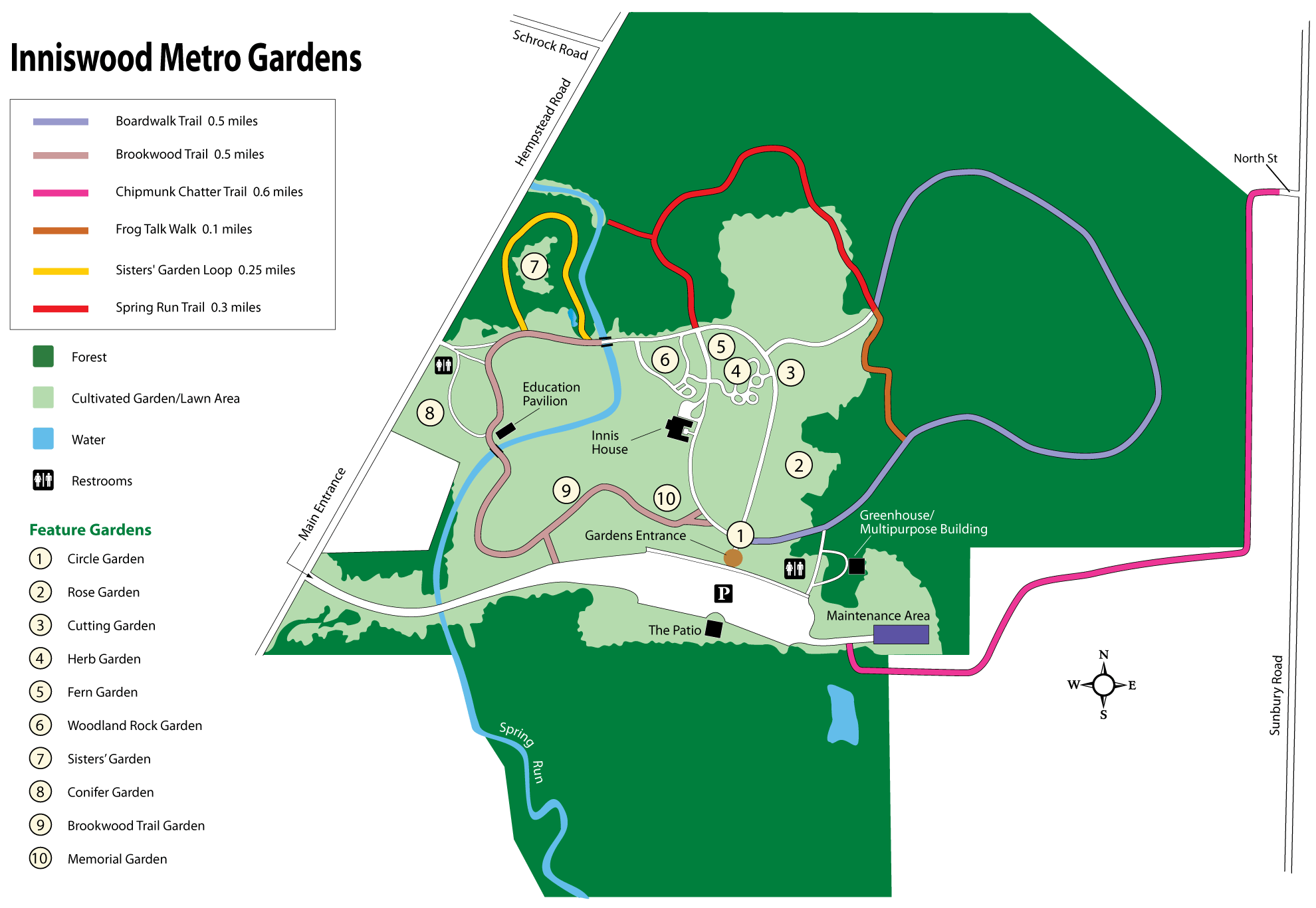
- Inniswood Metro Gardens (Metro Park)
-
- Official Site
- Trail Map
- Trail descriptions
- Posts at TrekOhio
- Inniswood Garden Society
- Location:
- 940 S. Hempstead Road, Westerville, Ohio 43081
- GPS coordinates: 40.1019732, -82.9035304
- View on Google Maps
- 123 acres in all
- 2.25 miles of total trail
- Facilities:
- Restroom facilities
- Handicap accessible
- Miscellaneous info: Park with extensive gardens. Inniswood is a trailhead for the Chipmunk Chatter Trail; you are allowed to bring your dog along on this trail, but you can’t take your dog anywhere else in the park.
- Olentangy Bike Trail (Bike Path)
-
- Official Site
- Trail Map for Upper Section
- Trail Map for Lower Section
- Brochure for the Olentangy River Water Trail
- 13 miles of paved, multi-use trail
- Supported activities:
- Bringing your dog
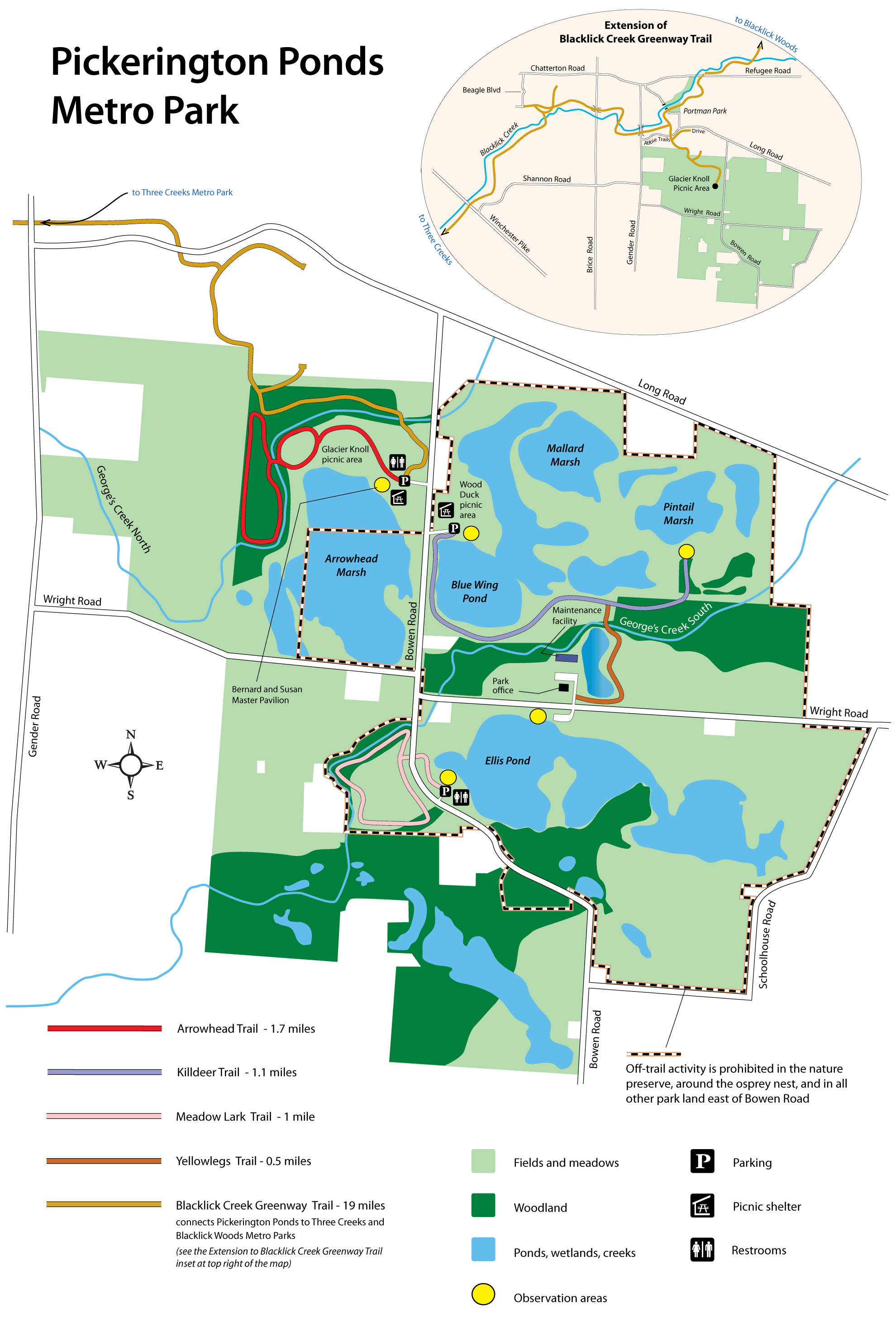
- Pickerington Ponds (Metro Park)
-
- Official Site
- Park Map
- Trail descriptions
- Posts at TrekOhio
- Location:
- 7680 Wright Road, Canal Winchester, Ohio 43110
- GPS coordinates: 39.8860621, -82.8030397
- View on Google Maps
- 1,608 acre in all
- 5.1 miles of total trail
- Supported activities:
- Good site for bird watching
- Facilities:
- Restroom facilities
- Handicap accessible
- Pickerington Ponds SNP (State Nature Preserve)
-
- Official Site
- 416 acres in all
- Miscellaneous info: The preserve is located within the Pickerington Ponds Metro Park, and the preserve is owned and managed by the Columbus/Franklin County Metro Parks system.
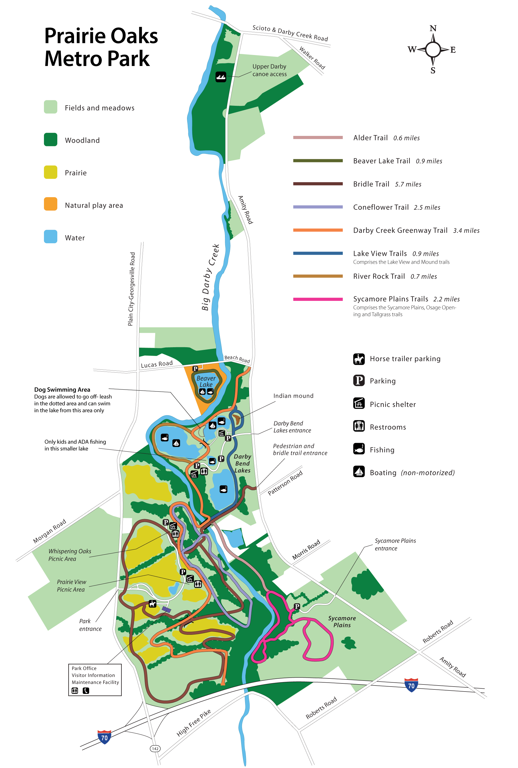
- Prairie Oaks (Metro Park)
-
- Official Site
- Trail Map
- Trail descriptions
- Location:
- 3225 Plain City-Georgesville Road, West Jefferson, Ohio 43162
- GPS coordinates: 39.9912772, -83.2683719
- View on Google Maps
- 2,203 acres in all
- Trail information:
- 8.5 miles of hiking / pet walking trail
- 5.7 miles of bridle / cross-country skiing trail
- 2.5 miles of hiking / cross-country skiing trail
- Supported activities:
- Fishing
- Cross-country skiing
- Horseback riding
- Bringing your dog
- Paddling
- Facilities:
- Restroom facilities
- Miscellaneous info: Pets are limited to designated trails, and the picnic areas. There is also a doggie swimming beach at Darby Bend Lakes.
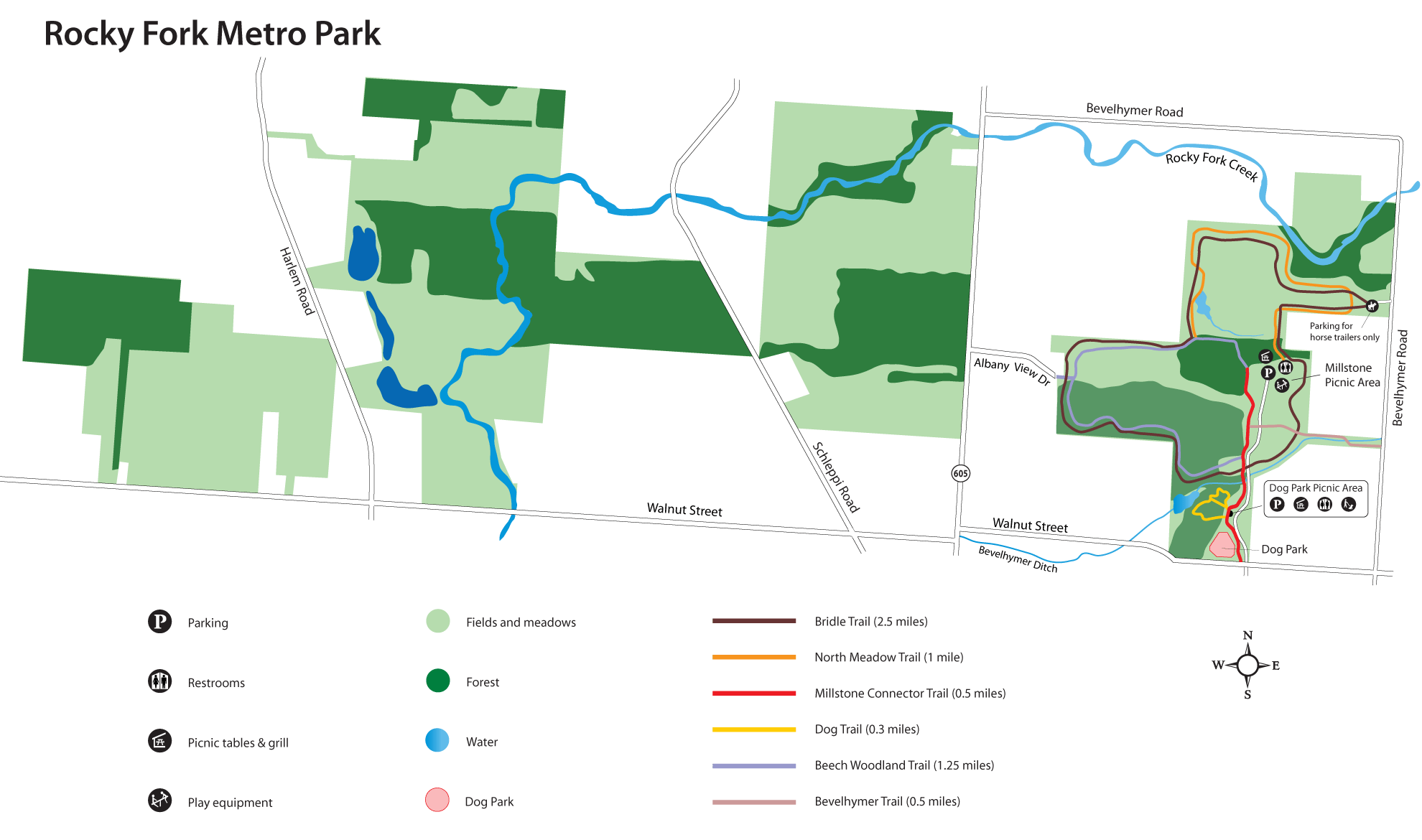
- Rocky Fork (Metro Park)
-
- Official Site
- Trail Map
- Trail descriptions
- Horse trailer parking:
- 8189 Bevelhymer Road, Columbus, Ohio 43081
- GPS coordinates: 40.1228301, -82.7970507
- View on Google Maps
- Main Entrance:
- 7180 Walnut Street, Columbus, Ohio 43081
- GPS coordinates: 40.114494, -82.8003228
- View on Google Maps
- 1,003 acre in all
- Trail information:
- More than 3 miles of walking trails
- About 2.5 miles of bridle trail
- Supported activities:
- Horseback riding
- Bringing your dog
- Facilities:
- Restroom facilities
- Handicap accessible
- Dog park
- Miscellaneous info: Play areas, picnic shelters
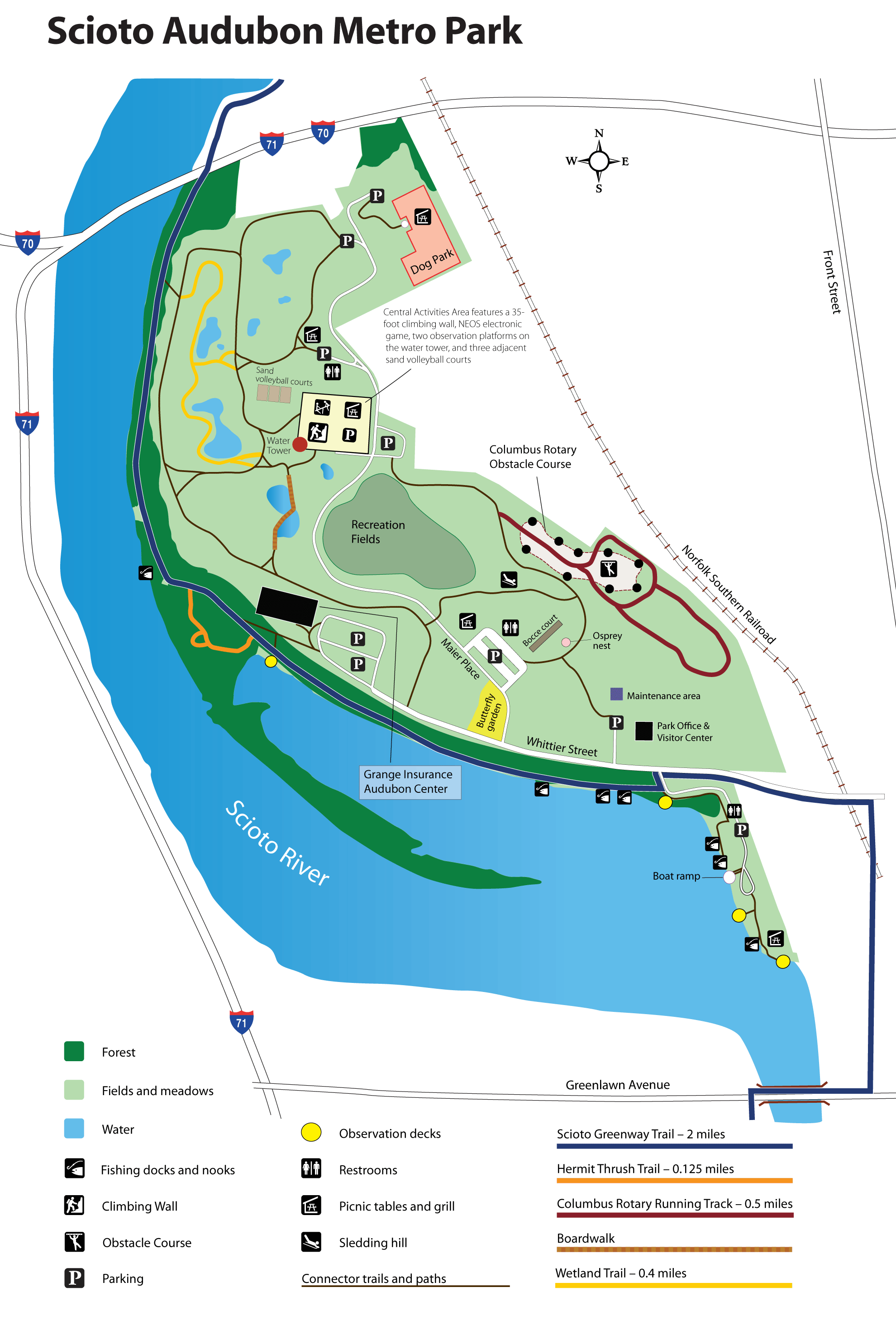
- Scioto Audubon (Metro Park)
-
- Official Site
- Trail Map
- Trail descriptions
- Location:
- 400 W. Whittier Street, Columbus, Ohio 43215
- 120 acres in all
- Trail information:
- 0.5 miles of hiking trail
- 12.5 miles of multi-use trail
- Supported activities:
- Fishing
- Sledding
- Rappelling
- Good site for bird watching
- Bringing your dog
- Paddling
- Boating with high horsepower motors
- Facilities:
- Restroom facilities
- Handicap accessible
- Nature center
- Miscellaneous info: There is a climbing wall consisting of three towers and two arches with the main climbing wall being 35 feet in height.
- Scioto Bike Trail (Bike Path)
-
- Official Site
- Trail Map
- 6 miles of paved, multi-use trail
- Miscellaneous info: One of the trailheads for this trail is located within the Scioto Audubon Metro Park; check out the official site for others.
- Scioto Grove (Metro Park)
-
- Official Site
- Trail Map
- Trail descriptions
- Location:
- 5172 Jackson Pike, Grove City, Ohio 43123
- GPS coordinates: 39.8555727, -83.0300579
- View on Google Maps
- 620 acres in all
- More than 7 miles of total trail
- Supported activities:
- Fishing
- Sledding
- Good site for bird watching
- Bringing your dog
- Paddling
- Backpacking
- Miscellaneous info: You must call and make a reservation to backpack: (614) 539-3339.
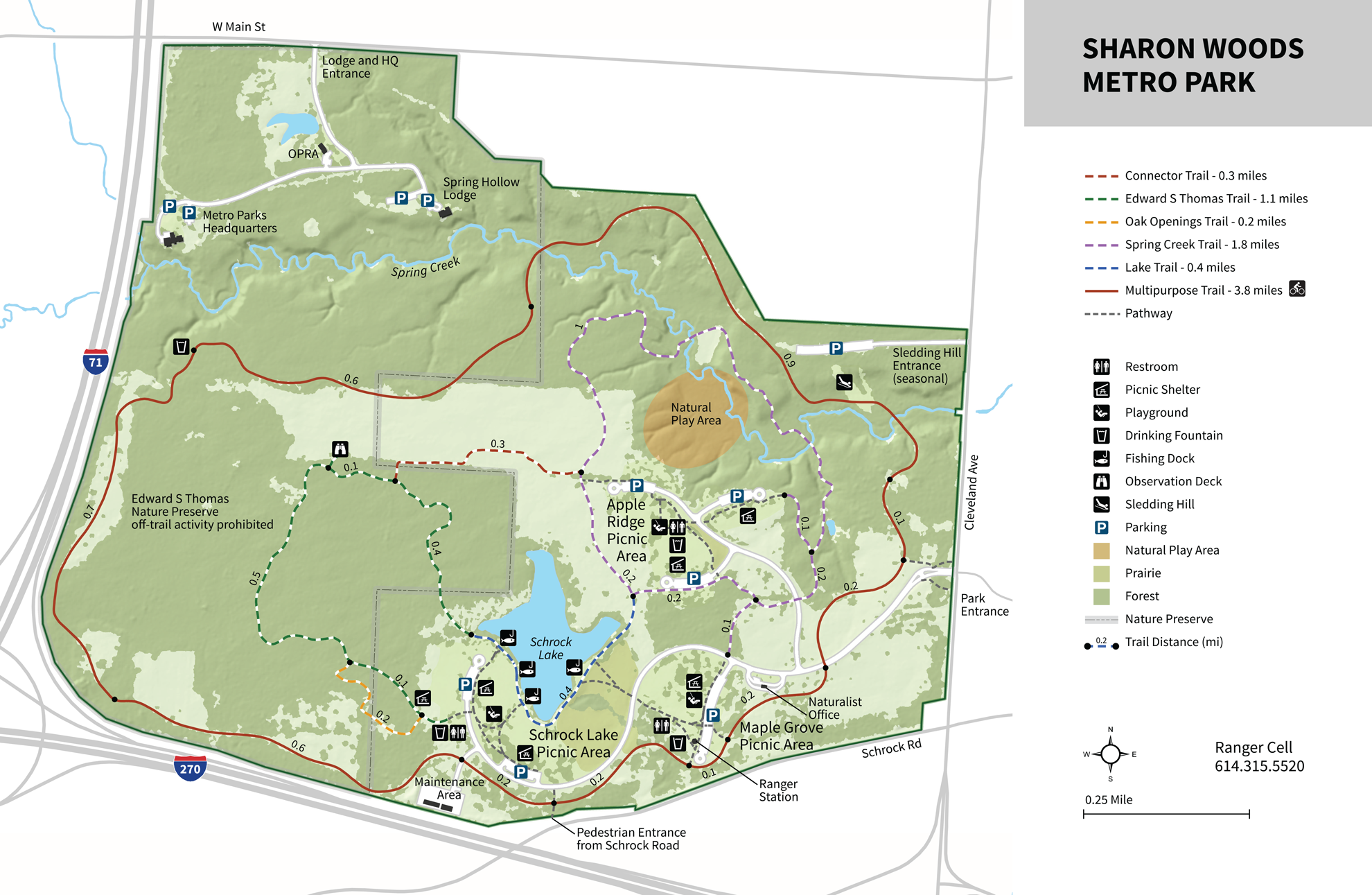
- Sharon Woods (Metro Park)
-
- Official Site
- Trail Map
- Trail descriptions
- Posts at TrekOhio
- Location:
- 6911 Cleveland Avenue, Westerville, Ohio 43081
- GPS coordinates: 40.114003, -82.949148
- View on Google Maps
- 761 acres in all
- 7 miles of total trail
- Supported activities:
- Fishing
- Sledding
- Good site for bird watching
- Bringing your dog
- Facilities:
- Restroom facilities
- Handicap accessible
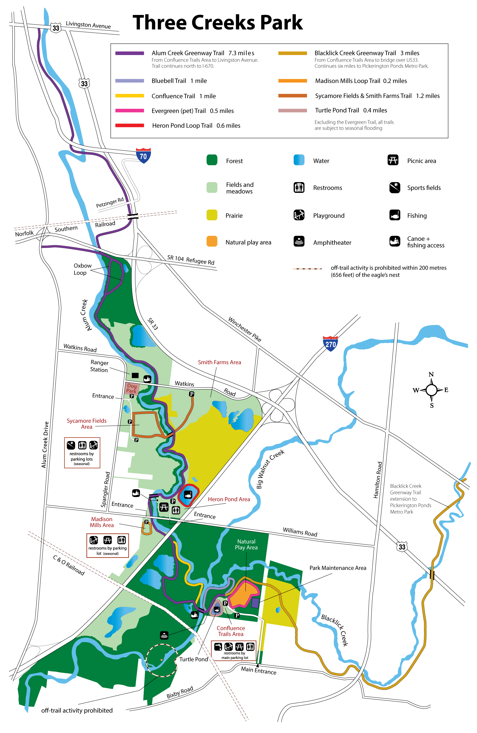
- Three Creeks (Metro Park)
-
- Official Site
- Trail Map
- Trail descriptions
- Location:
- 3860 Bixby Road, Groveport, Ohio 43125
- 1,100 acre in all
- 19 miles of total trail
- Supported activities:
- Fishing
- Good site for bird watching
- Bringing your dog
- Paddling
- Facilities:
- Restroom facilities
- Handicap accessible
- Miscellaneous info: Park connects to both Alum Creek and Blacklick Creek Greenways (bike paths)
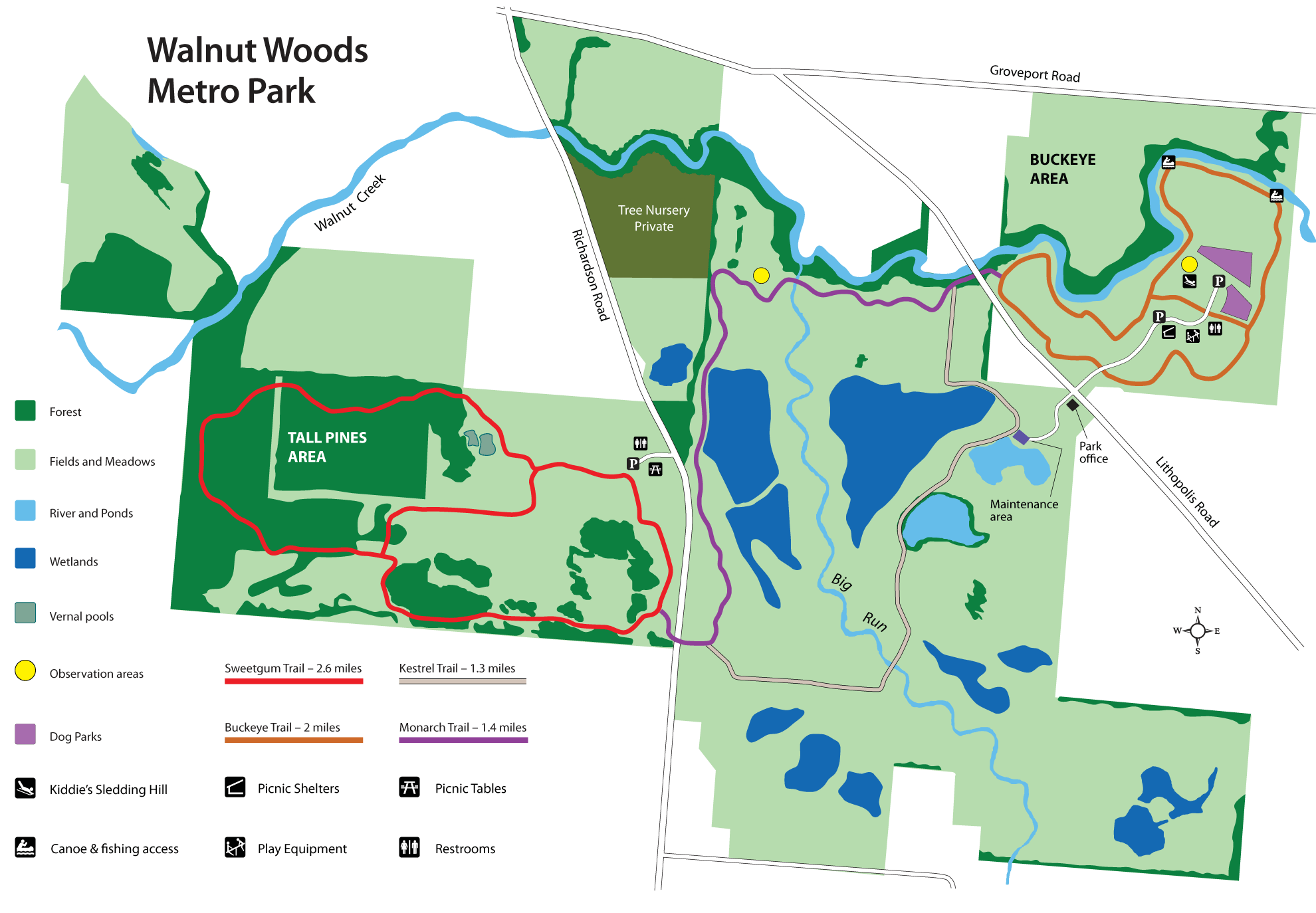
- Walnut Woods (Metro Park)
-
- Official Site
- Trail Map
- Posts at TrekOhio
- Tall Pines Area:
- 6833 Richardson Road, Groveport, Ohio 43125
- GPS coordinates: 39.838859, -82.870231
- View on Google Maps
- Buckeye Area:
- 6716 Lithopolis Road, Groveport, Ohio 43125
- GPS coordinates: 39.842616, -82.853236
- View on Google Maps
- 1,098 acre in all
- 2.6 miles of total trail
- Supported activities:
- Fishing
- Sledding
- Bringing your dog
- Paddling
- Facilities:
- Restroom facilities
- Westerville Bike Trails (Bike Path)
-
- Official Site
- Brochure
- Information on Snow Removal
- 44 miles of paved, multi-use trails
- Supported activities:
- Bringing your dog
- Facilities:
- Handicap accessible
Last Update: Jun 21, 2018
© Deborah Platt, Robert Platt and TrekOhio.com 2012 to 2021