The following list of parks and preserves includes those managed by federal, state, county, and non-governmental agencies (such as the National Audubon Society, the Nature Conservancy, various historical societies, etc.).
We have tried to collect information on the activities and facilities available at various parks, but things may change without us knowing about it. So please double-check the information at the official site.
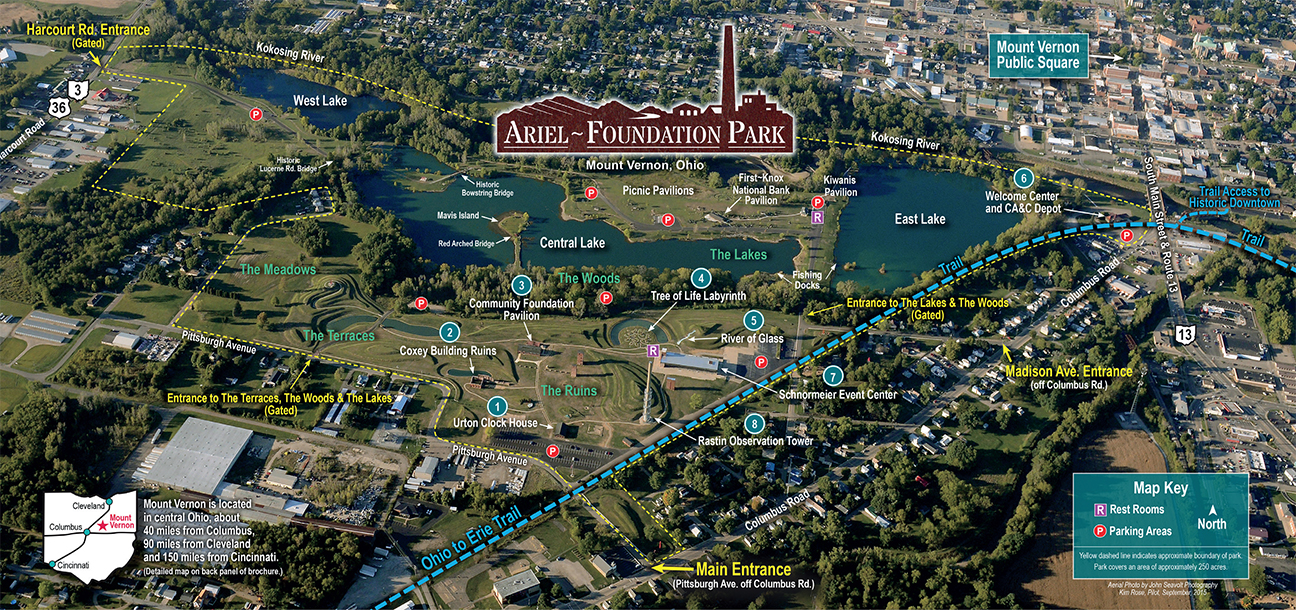
- Ariel-Foundation Park (Foundation Park Conservancy)
-
- Official Site
- Park Map
- Posts at TrekOhio
- Location:
- 100 Pittsburgh Ave., Mt Vernon, Ohio 43050
- GPS coordinates: 40.382564, -82.497169
- View on Google Maps
- 250 acres in all
- Unspecified mileage of walking trails
- Supported activities:
- Fishing
- Camping
- Bringing your dog
- Miscellaneous info: Artistic commemoration of the area’s industrial past: the River of Glass commemorates the Chattanooga Glass company that used to make Coca-cola bottles; the Ruins and the Urton Clock House commemorate the Pittsburgh Plate Glass manufacturing plant. A former smokestack has been converted into an observation tower with a viewing platform 140 feet above the park. Three gravel quarries varying from 10 to 85 feet in depth are now ponds that are stocked yearly with Rainbow Trout, Yellow Perch and Hybrid Bluegill. Canoes, kayaks and boats with motors are allowed in the ponds. Paved pedestrian walkways include the Tree of Life Labyrinth. The park connects with the Heart of Ohio Trail and in the future will connect with the Kokosing Gap trail.
- Bat Nest Park and Riley Chapel Road Access (County Park)
-
- Official Site
- Gravel parking lot:
- 30500 Walhonding Rd. (State Route 715), Danville, Ohio 43014
- Paddle sports access parking lot:
- 10300 Riley Chapel Rd., Walhonding, Ohio 43843
- 133 acres in all
- Supported activities:
- Good site for bird watching
- Paddling
- Miscellaneous info: Zane State College Students put in 100s of hours constructing the bat house with the assistance of Knox County Career Center ROTC students and Knox County’s Ohio Certified Volunteer Naturalists. Bald Eagles hunt for food along this stretch of the Kokosing River.
- Heart of Ohio Trail (Bike Path)
-
- Official Site
- Trail Map
- More than 15 miles of paved, multi-use trail
- Supported activities:
- Bringing your dog
- Miscellaneous info: During stormy weather, occasionally branches and/or trees fall across the trail. To report on these (or other issues), call (740) 392-7275.
- Hellbender Preserve (County Park)
-
- Official Site
- Location at mapquest.com
- Location:
- 23316 Coshocton Ave, Howard, Ohio 43028
- 15 acres in all
- Supported activities:
- Good site for bird watching
- Miscellaneous info: Accessed via the Kokosing Gap Trail. Named for Ohio’s largest amphibian, the Hellbender salamander. Nice display of spring wildflowers.
- Honey Run Highlands Park (County Park)
-
- Official Site
- Posts at TrekOhio
- Honey Run Waterfall
- Waterfall Parking Lot:
- 10865 Hazel Dell Road, Howard, Ohio 43028
- GPS coordinates: 40.383424, -82.266951
- View on Google Maps
- Picnic site with pergola shade structure and grill:
- 10816 Millersburg Rd., Howard, Ohio 43028
- 370 acres in all
- More than 4.5 miles of total trail
- Supported activities:
- Good site for bird watching
- Miscellaneous info: 25-foot waterfall; Archery hunting by permit-only during Ohio’s white-tailed deer archery season.
- Indianfield Bluffs Park (County Park)
-
- Official Site
- Posts at TrekOhio
- Location:
- 10855 Sapp Road, Howard, Ohio 43028
- 25 acres in all
- More than 1.5 miles of total trail
- Supported activities:
- Good site for bird watching
- Miscellaneous info: Archery hunting by permit-only during Ohio’s white-tailed deer archery season. Best view from the bluff is after the trees have dropped their leaves in the fall, or before new foliage emerges in the spring. Cedar Waxwing Island is located in the park within the Kokosing State Scenic River.
- Knox Woods (State Nature Preserve)
-
- Official Site
- Posts at TrekOhio
- Location:
- 17604 Coshocton Road, Mt. Vernon, Ohio 43050
- GPS coordinates: 40.3972208, -82.4307387
- View on Google Maps
- 30 acres in all
- Supported activities:
- Good site for bird watching
- Prohibited activities:
- Fishing not permitted
- Horseback riding not permitted
- Facilities:
- No restroom facilities
- Not handicap accessible
- Miscellaneous info: The site is managed by the Knox County Park District. It is adjacent to Wolf Run Park with which it shares some trails.
- Kokosing Gap Trail (Bike Path)
-
- Official Site
- Trail Map
- More than 13 miles of paved, multi-use trail
- Supported activities:
- Bringing your dog
- Facilities:
- Restroom facilities
- Kokosing Lake (State Wildlife Area)
-
- Official Site
- Map for Fishing
- Enhanced Map for Fishing
- Location:
- On SR-13, 2 miles north of SR-13 & Waterford Road, Fredericktown, Ohio
- 1,323 acre in all
- Supported activities:
- Fishing
- Hunting
- Camping
- Good site for bird watching
- Low-horsepower boating (depending on the park, this may mean boats with electric motors, boats whose motors do not exceed a specific horsepower, or boats with any horsepower motor as long as no wake is generated; check the official site for details)
- Prohibited activities:
- Horseback riding not permitted
- Miscellaneous info: The campground is managed by the Muskingum Watershed Conservancy District.
- Mohican River Wildlife Area (State Wildlife Area)
-
- Official Site
- Wildlife Area Map
- 474 acres in all
- Supported activities:
- Fishing
- Hunting
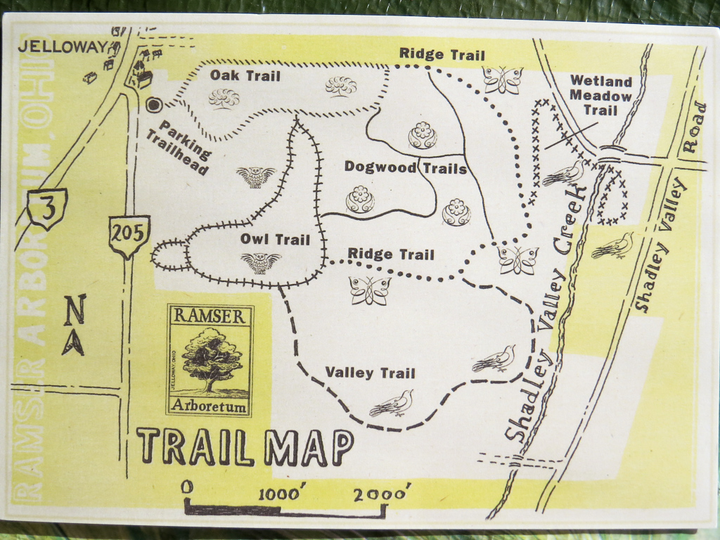
- Ramser Arboretum (Botanical Garden)
-
- Official Site
- Trail Map
- Posts at TrekOhio
- Location:
- 24565 Danville-Jelloway Road, Danville, Ohio
- GPS coordinates: 40.536131, -82.299086
- View on Google Maps
- 680 acres in all
- More than 5 miles of total trail
- Supported activities:
- Good site for bird watching
- Thayer Ridge Park (County Park)
-
- Official Site
- Posts at TrekOhio
- Location:
- 7077 Thayer Road, Mount Vernon, Ohio
- 70 acres in all
- Trail information:
- Unspecified mileage of hiking trails
- Unspecified mileage of bridle trails
- Unspecified mileage of mountain biking trails
- Supported activities:
- Mountain biking
- Good site for bird watching
- Horseback riding
- Bringing your dog
- Facilities:
- Disc golf course
- Miscellaneous info: Archery hunting by permit-only during Ohio’s white-tailed deer archery season.
- Wolf Run Regional Park (County Park)
-
- Official Site
- Posts at TrekOhio
- Location:
- 18000 Yauger Rd, Mount Vernon, Ohio 43050
- About 260 acres in all
- Nearly 10 miles of total trail
- Supported activities:
- Fishing
- Good site for bird watching
- Bringing your dog
- Facilities:
- Dog park
- Miscellaneous info: Archery hunting by permit-only during Ohio’s white-tailed deer archery season.
Last Update: Jun 20, 2018
© Deborah Platt, Robert Platt and TrekOhio.com 2012 to 2021
Is there maps if the parks to print out? Cant find them on your site. Would be helpful so I know how long the trail is before heading out, especially with little kids.
Thanks
Carol, if we were able to find an online map for a park, a link will appear under that park’s name with the words “Trail map.” If you click the link you will typically be prompted to view or download a PDF file. In some cases, I have been able to find an image of the trail on the web, so the link will instead bring up what passes for a map as an image. After reading your comment, I noted that we photographed a map for Ramser Arboretum while visiting there and included the photograph in our review of the site. I went ahead in that case and linked to our own photo of the map.
The government of Ohio typically does not publish online trail maps for our state nature preserves. If we have hiked there, we typically make a GPS trace of our hike which can serve as a map. So if you wanted to go to Knox Woods, you would click on the link labeled, “TrekOhio photos and descriptions of Knox Woods”. This brings up a teaser for the article. Click “Read more…” and at the bottom of the article is a GPS trace of the hike.
Hope this helps!