The following list of parks and preserves includes those managed by federal, state, county, and non-governmental agencies (such as the National Audubon Society, the Nature Conservancy, various historical societies, etc.).
We have tried to collect information on the activities and facilities available at various parks, but things may change without us knowing about it. So please double-check the information at the official site.
- Bigelow Cemetery (State Nature Preserve)
-
- Official Site
- Posts at TrekOhio
- Location:
- 600 Rosedale Rd., Irwin, Ohio 43029
- GPS coordinates: 40.109617, -83.419117
- View on Google Maps
- About 1 acre in all
- 0.5 miles of total trail
- Miscellaneous info: Because this site contains a pioneer cemetery, the land was never farmed. As a result it has preserved a number of rare, prairie wildflowers such as royal catchfly. Peak bloom is late July through August.
- Deer Creek Wildlife Area (State Wildlife Area)
-
- Official Site
- Wildlife Area Map
- Location:
- GPS coordinates: 39.6400126, -83.2715176
- View on Google Maps
- Area:
- 4,220 acres in all
- 1,000 acre crop land
- Supported activities:
- Fishing
- Hunting
- Good site for bird watching
- Boating with high horsepower motors
- Miscellaneous info: APV riding area
- Heritage Trail Park (Metro Park (Bike Path))
-
- Official Site
- Trail descriptions
- Map at MyHikes.org
- Location:
- 7262 Hayden Run Road, Hilliard, Ohio 43026
- GPS coordinates: 40.0620499, -83.2030106
- View on Google Maps
- 87 acres in all
- Trail information:
- 6.1 miles of paved, multi-use trail (hiking / cycling / pet walking)
- 3.6 miles of bridle trail
- Supported activities:
- Horseback riding
- Bringing your dog
- Miscellaneous info: Adjacent to the Heritage Rail Trail, a 6.1-mile multi-purpose trail
- Little Darby State Scenic River Preserve (County Park)
-
- Official Site
- Trail Map
- Location:
- 5995 Lafayette Plain City Rd., London, Ohio 43140
- GPS coordinates: 40.0232952, -83.3921329
- View on Google Maps
- 214 acres in all
- Trail information:
- 1 miles of mowed grass trail now
- 1 miles of additional trail when complete
- Prohibited activities:
- Hunting not permitted
- London Fish Hatchery (State Fish Hatchery)
-
- Official Site
- Location:
- 2470 Roberts Mill Rd., London, Ohio 43140
- GPS coordinates: 39.8982471, -83.5124477
- View on Google Maps
- 80 acres in all
- Madison Lake (State Park)
-
- Official Site
- Hunting Map
- Park Map
- Location:
- 4860 E Park Drive, London, Ohio 43140
- GPS coordinates: 39.8705496, -83.3758019
- View on Google Maps
- Area:
- 76 acres park
- 106 acres lake
- 1 miles of total trail
- Supported activities:
- Fishing
- Hunting
- Good site for bird watching
- Bringing your dog
- Low-horsepower boating (depending on the park, this may mean boats with electric motors, boats whose motors do not exceed a specific horsepower, or boats with any horsepower motor as long as no wake is generated; check the official site for details)
- Facilities:
- Restroom facilities
- Swimming beach
- Miscellaneous info: There is a dog swim area on the east side of the lake.
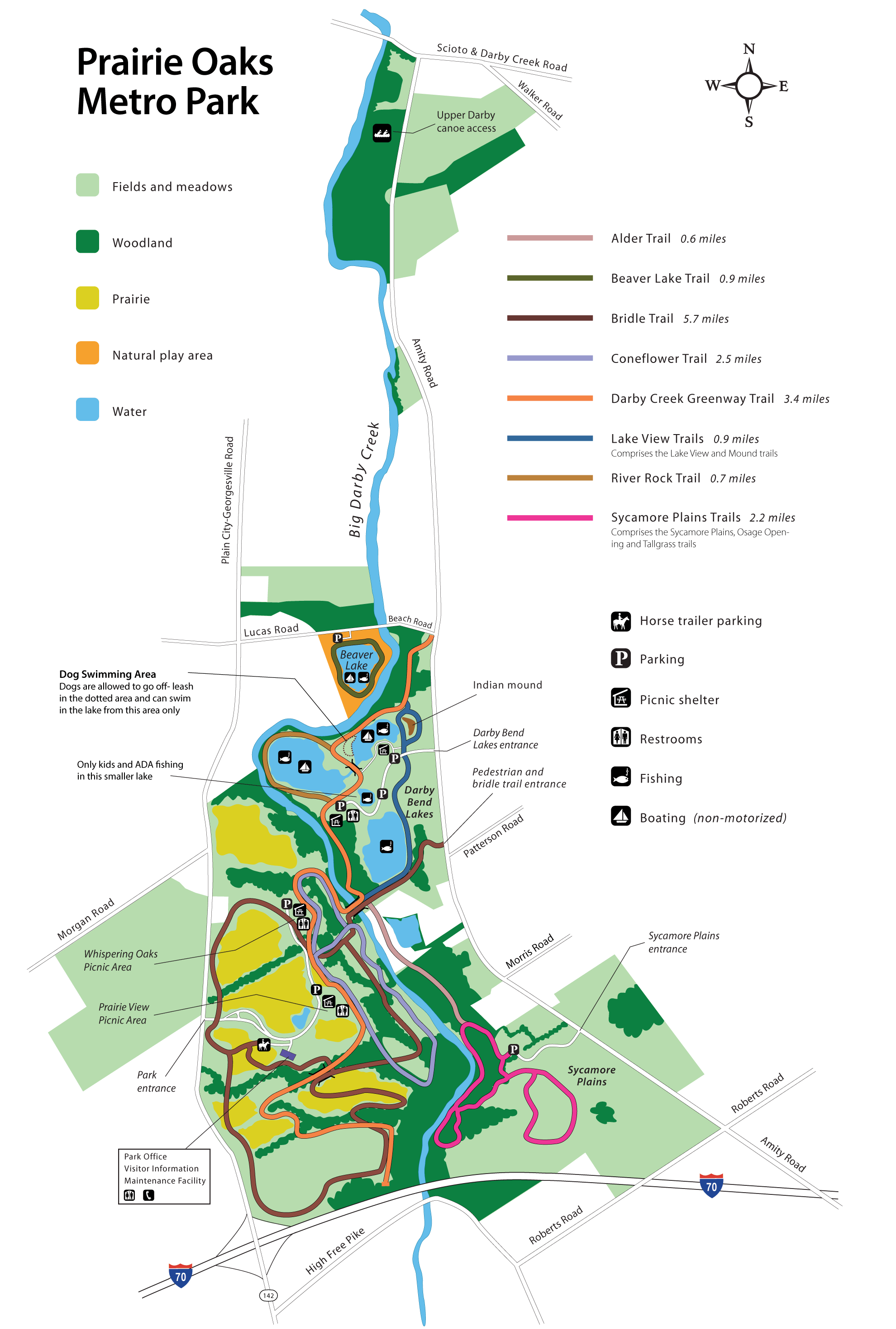
- Prairie Oaks (Metro Park)
-
- Official Site
- Trail Map
- Trail descriptions
- Location:
- 3225 Plain City-Georgesville Road, West Jefferson, Ohio 43162
- GPS coordinates: 39.9912772, -83.2683719
- View on Google Maps
- 2,203 acres in all
- Trail information:
- 8.5 miles of hiking / pet walking trail
- 5.7 miles of bridle / cross-country skiing trail
- 2.5 miles of hiking / cross-country skiing trail
- Supported activities:
- Fishing
- Cross-country skiing
- Horseback riding
- Bringing your dog
- Paddling
- Facilities:
- Restroom facilities
- Smith Cemetery (State Nature Preserve)
-
- Official Site
- Posts at TrekOhio
- Location:
- 4400 Boyd Rd., Plain City, Ohio 43064
- GPS coordinates: 40.103071, -83.324350
- View on Google Maps
- 1 acre in all
- Miscellaneous info: Since the site contains a pioneer cemetery, it was never farmed. As a result it preserves the original prairie wildflowers that once dominated the area.
Last Update: Jun 21, 2018
© Deborah Platt, Robert Platt and TrekOhio.com 2012 to 2021
There is a fence up at the little Darby preserve parking area. Is there no longer fishing access to the creek? What’s up with this? I’ve used this access for years.