By visiting Blackhand Gorge Nature Preserve, you can trace Ohio's long history of transportation.
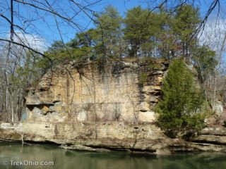
Native Americans navigated the Licking River for centuries before the arrival of European settlers. There is a cliff made of Blackhand sandstone rising on the north side of the Licking River. In prehistoric times, Native Americans inscribed a petroglyph on this cliff; it looked like a very large, black hand. Not only is the gorge named after this petroglyph, but the class of erosion-resistant sandstone
Read more ➜
 Lockville Park is a 6 acre park in Fairfield County containing the ruins of three locks from what was once the Ohio & Erie Canal. The park also has a covered bridge that was constructed in 1888.
If you look at a map of Ohio, you'll see Lake Erie on the northern edge. The irregular southern edge is formed by the Ohio River. The Ohio River feeds into the Mississippi River which flows into the Gulf of Mexico. Both the Ohio River and Lake Erie provided convenient water transportation Read more ➜
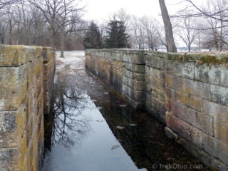
Lockville Park is a 6 acre park in Fairfield County containing the ruins of three locks from what was once the Ohio & Erie Canal. The park also has a covered bridge that was constructed in 1888.
If you look at a map of Ohio, you'll see Lake Erie on the northern edge. The irregular southern edge is formed by the Ohio River. The Ohio River feeds into the Mississippi River which flows into the Gulf of Mexico. Both the Ohio River and Lake Erie provided convenient water transportation Read more ➜