The following list of parks and preserves includes those managed by federal, state, county, and non-governmental agencies (such as the National Audubon Society, the Nature Conservancy, various historical societies, etc.).
We have tried to collect information on the activities and facilities available at various parks, but things may change without us knowing about it. So please double-check the information at the official site.
- Alum Creek (State Park)
-
- Official Site
- Trail Map
- Campground Map
- Hunting Map
- Park Map
- Park Office:
- 3307 S. Old State Rd., Delaware, Ohio 43015
- GPS coordinates: 40.2322177, -82.9819461
- View on Google Maps
- Campground:
- 2911 S Old State Rd, Delaware, Ohio 43015
- GPS coordinates: 40.2388308, -82.986551
- View on Google Maps
- Marina:
- 4000 Hollenback Rd., Lewis Center, Ohio 43035
- GPS coordinates: 40.2104672, -82.9730582
- View on Google Maps
- Beach:
- 3400 Lewis Center Rd., Lewis Center, Ohio 43035
- GPS coordinates: 40.1908178, -82.9764865
- View on Google Maps
- Mountain Bike Trail Parking:
- 6002 County Rd 106, Galena, Ohio 43021
- GPS coordinates: 40.1993889, -82.9380556
- View on Google Maps
- Disc Golf Course:
- 4450 Africa Rd., Galena, Ohio 43021
- GPS coordinates: 40.1984963, -82.9489173
- View on Google Maps
- Area:
- 4,630 acres fields and woodlands
- 3,387 acres reservoir
- Trail information:
- 7.1 miles of hiking trail
- 38 miles of bridle trail
- 7 miles of multi-use trail (hiking, snowmobile, dog sledding, cross-country skiing)
- 14 miles of mountain biking trail
- Supported activities:
- Fishing
- Hunting
- Camping
- Mountain biking
- Cross-country skiing
- Sledding
- Horseback riding
- Bringing your dog
- Boating with high horsepower motors
- Ice skating
- Facilities:
- Disc golf course
- Swimming beach
- Dog park
- Miscellaneous info: Equestrian trail and camp
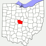
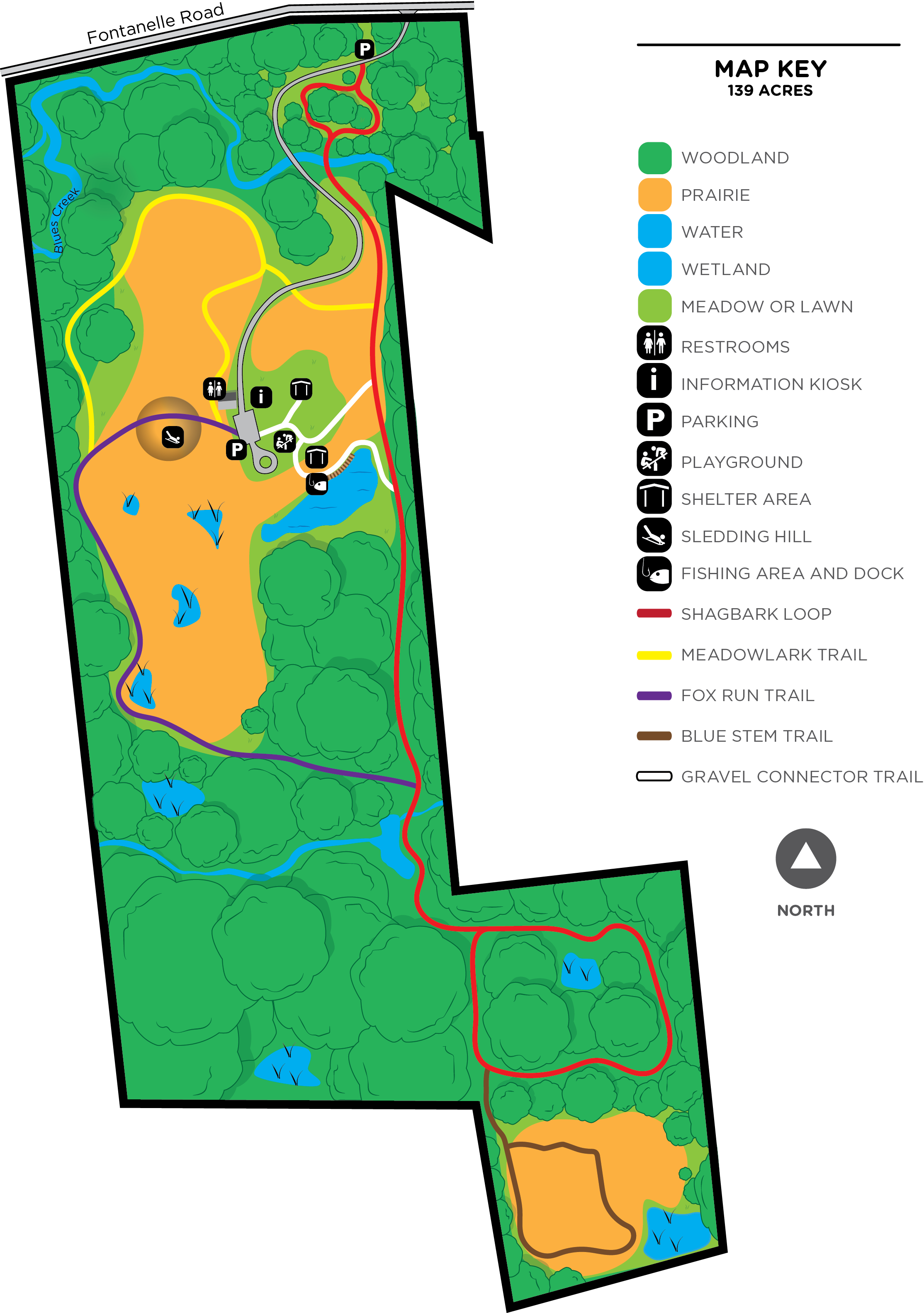
- Blues Creek Preserve (County Park)
-
- Official Site
- Trail Map
- Location:
- 9627 Fontanelle Road, Ostrander, Ohio 43061
- GPS coordinates: 40.283681, -83.239881
- View on Google Maps
- 138 acres in all
- 2.5 miles of total trail
- Supported activities:
- Fishing
- Sledding
- Bringing your dog
- Facilities:
- Restroom facilities
- Miscellaneous info: No fishing license required for doing catch-and-release fishing in pond (no age restrictions).
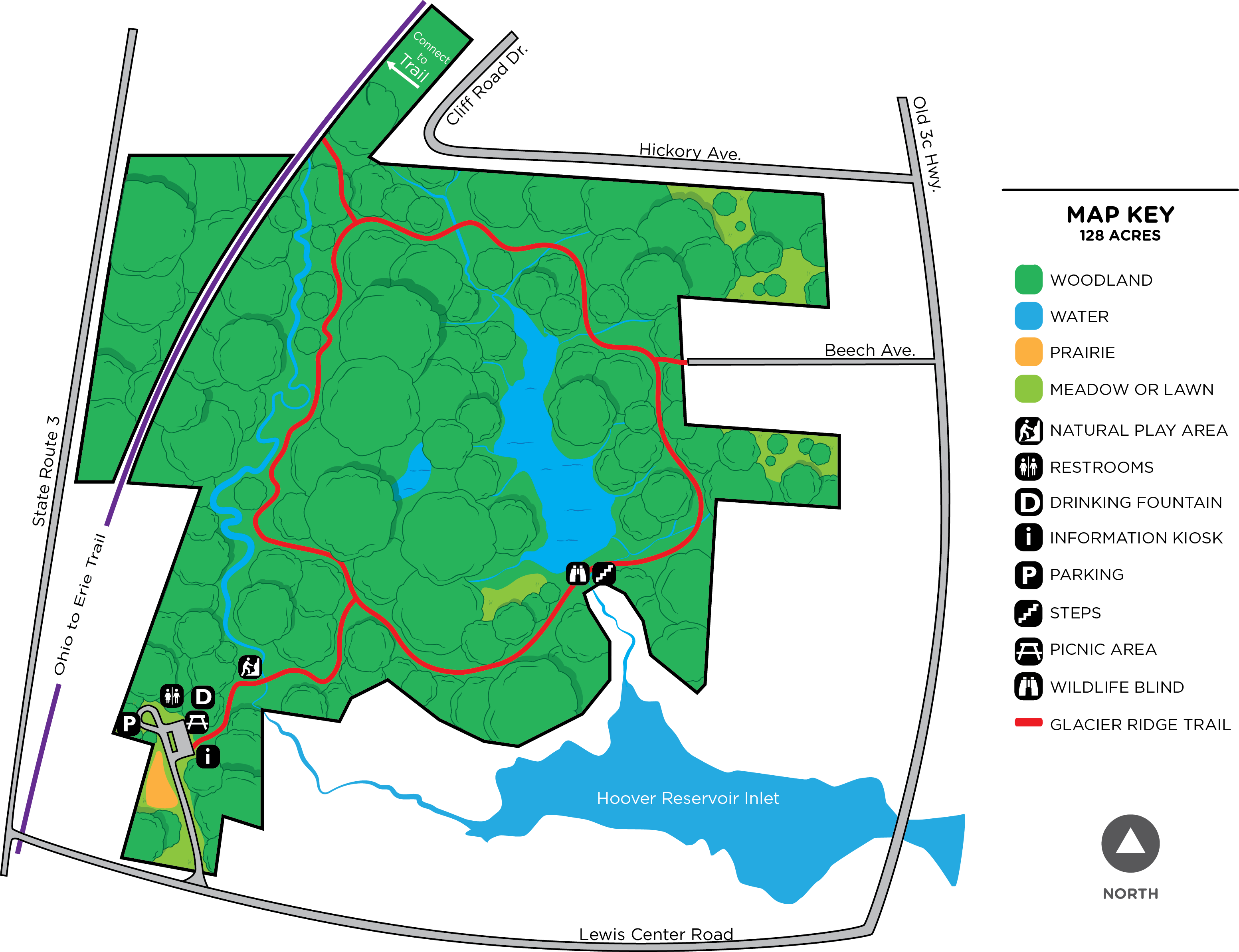
- Char-Mar Ridge Preserve (County Park)
-
- Official Site
- Trail Map
- Posts at TrekOhio
- Location:
- 7741 Lewis Center Road, Westerville, Ohio 43082
- GPS coordinates: 40.196081, -82.905075
- View on Google Maps
- 128 acres in all
- 1.75 miles of total trail
- Supported activities:
- Cross-country skiing
- Good site for bird watching
- Bringing your dog
- Miscellaneous info: Large pond with wildlife-viewing blind; nearby bird feeders attract a variety of species.
- Columbus Zoo & Aquarium (Zoo / Aquarium)
-
- Official Site
- Trail Map
- Posts at TrekOhio
- Location:
- 4850 West Powell Rd., Powell, Ohio 43065
- 580 acres in all
- Facilities:
- Restroom facilities
- Handicap accessible
- Golf course
- Miscellaneous info: Named #1 US Zoo by USA Travel Guide
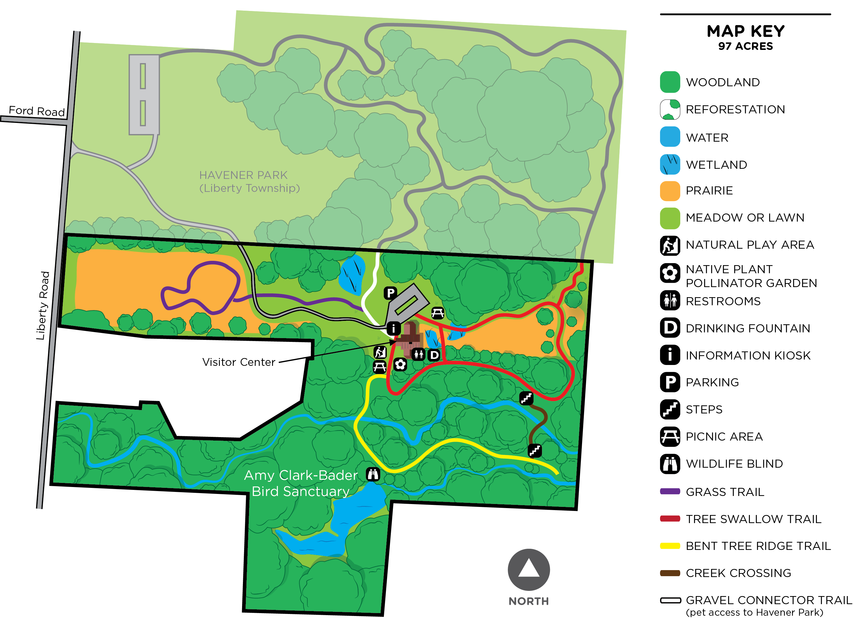
- Deer Haven Preserve (County Park)
-
- Official Site
- Trail Map
- Location:
- 4183 Liberty Road, Delaware, Ohio 43015
- GPS coordinates: 40.241428, -83.076039
- View on Google Maps
- 97 acres in all
- 1.5 miles of total trail
- Supported activities:
- Good site for bird watching
- Bringing your dog
- Facilities:
- Visitor center
- Delaware (State Park)
-
- Official Site
- Trail Map
- Campground Map
- Hunting Map
- Park Map
- Location:
- 5202 US Route 23 North, Delaware, Ohio 43015
- Area:
- 1,686 acre park
- 1,300 acre reservoir
- 5.85 miles of total trail
- Supported activities:
- Fishing
- Hunting
- Camping
- Cross-country skiing
- Sledding
- Good site for bird watching
- Bringing your dog
- Boating with high horsepower motors
- Ice skating
- Prohibited activities:
- Horseback riding not permitted
- Facilities:
- Disc golf course
- Swimming beach
- Miscellaneous info: Adjacent to Delaware Wildlife Area
- Delaware Wildlife Area (State Wildlife Area)
-
- Official Site
- Wildlife Area Map
- Location:
- GPS coordinates: 40.4077697, -83.0434647
- View on Google Maps
- Area:
- 4,670 acres in all
- 159 acres marsh
- Supported activities:
- Fishing
- Hunting
- Good site for bird watching
- Bringing your dog
- Boating with high horsepower motors
- Facilities:
- Handicap accessible
- Archery range
- Firearm range
- Miscellaneous info: The following facilities are accessible for those with disabilities: rifle, handgun, and shotgun shooting ranges with restrooms, and an archery range.
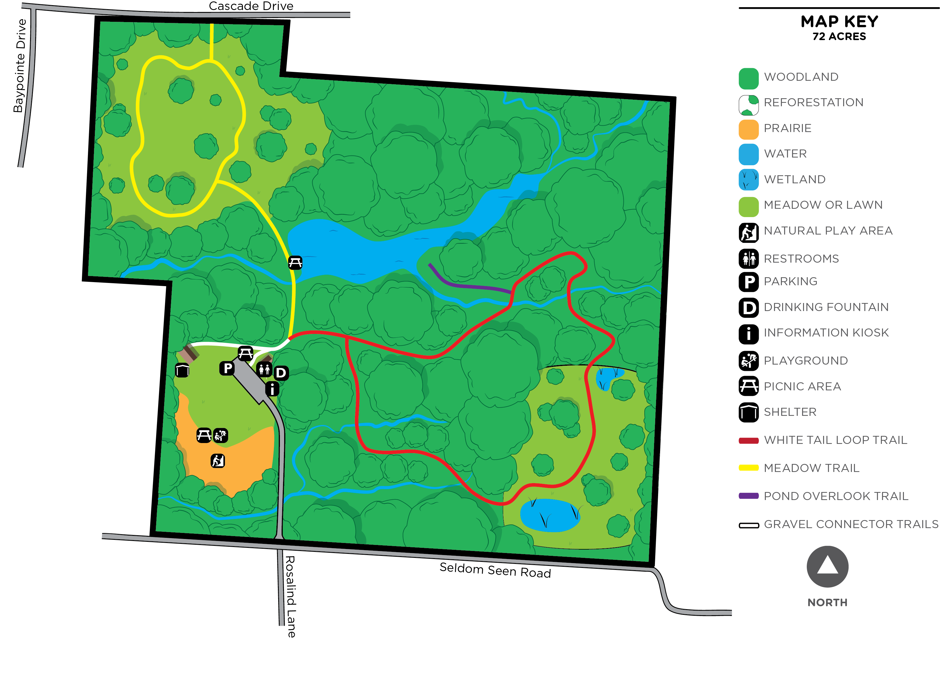
- Emily Traphagen Preserve (County Park)
-
- Official Site
- Trail Map
- Posts at TrekOhio
- Location:
- 5094 Seldom Seen Rd, Powell, Ohio 43065
- GPS coordinates: 40.171354, -83.1210007
- View on Google Maps
- 72 acres in all
- 1.2 miles of total trail
- Supported activities:
- Good site for bird watching
- Bringing your dog
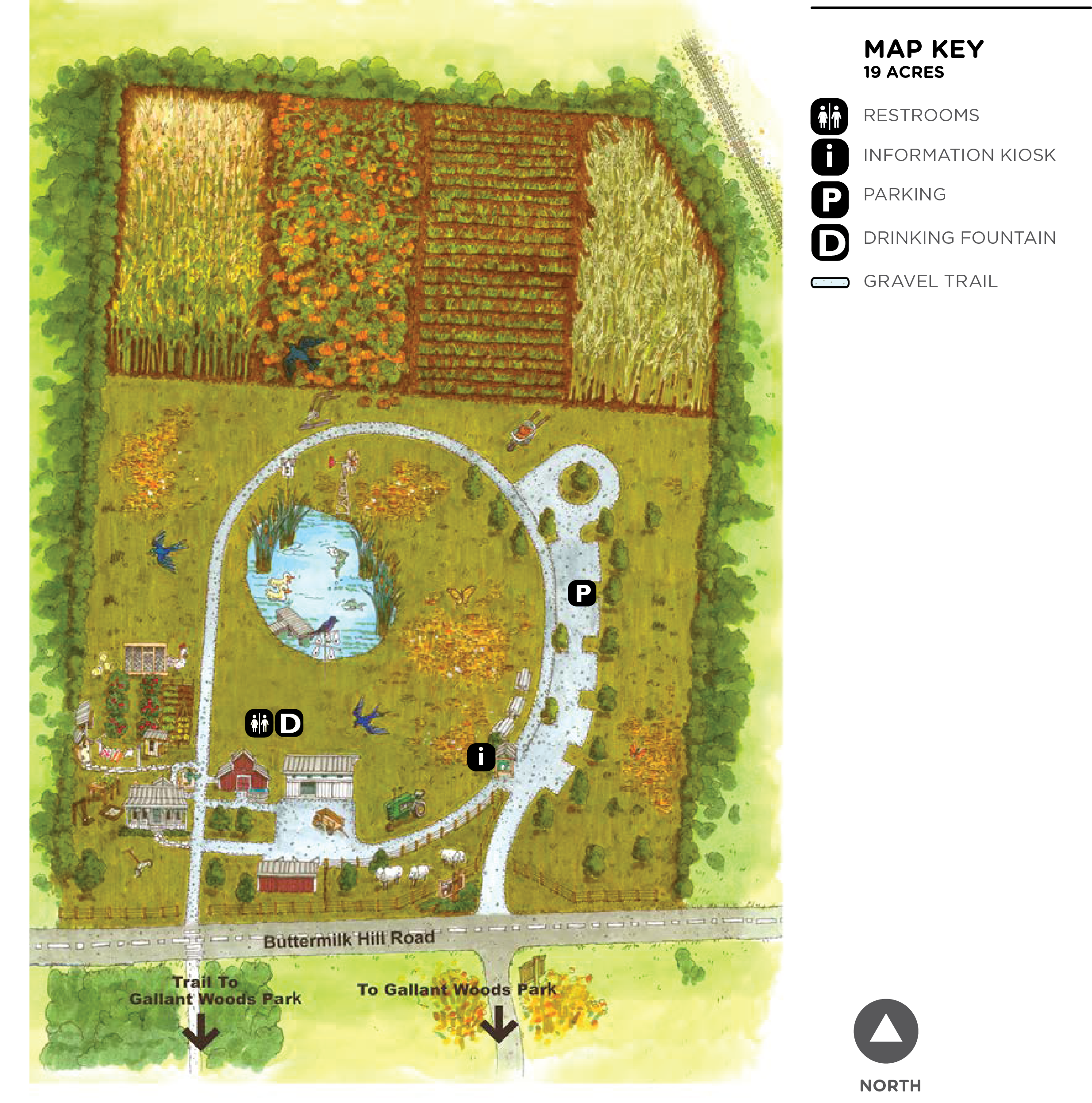
- Gallant Farm Preserve (County Park)
-
- Official Site
- Trail Map
- Location:
- 2150 Buttermilk Hill Road, Delaware, Ohio 43015
- GPS coordinates: 40.351123, -83.11473
- View on Google Maps
- 19 acres in all
- 0.25 miles of total trail
- Facilities:
- Historic farm
- Miscellaneous info: There is a working farm that recreates farm life from the Great Depression/WWII era.
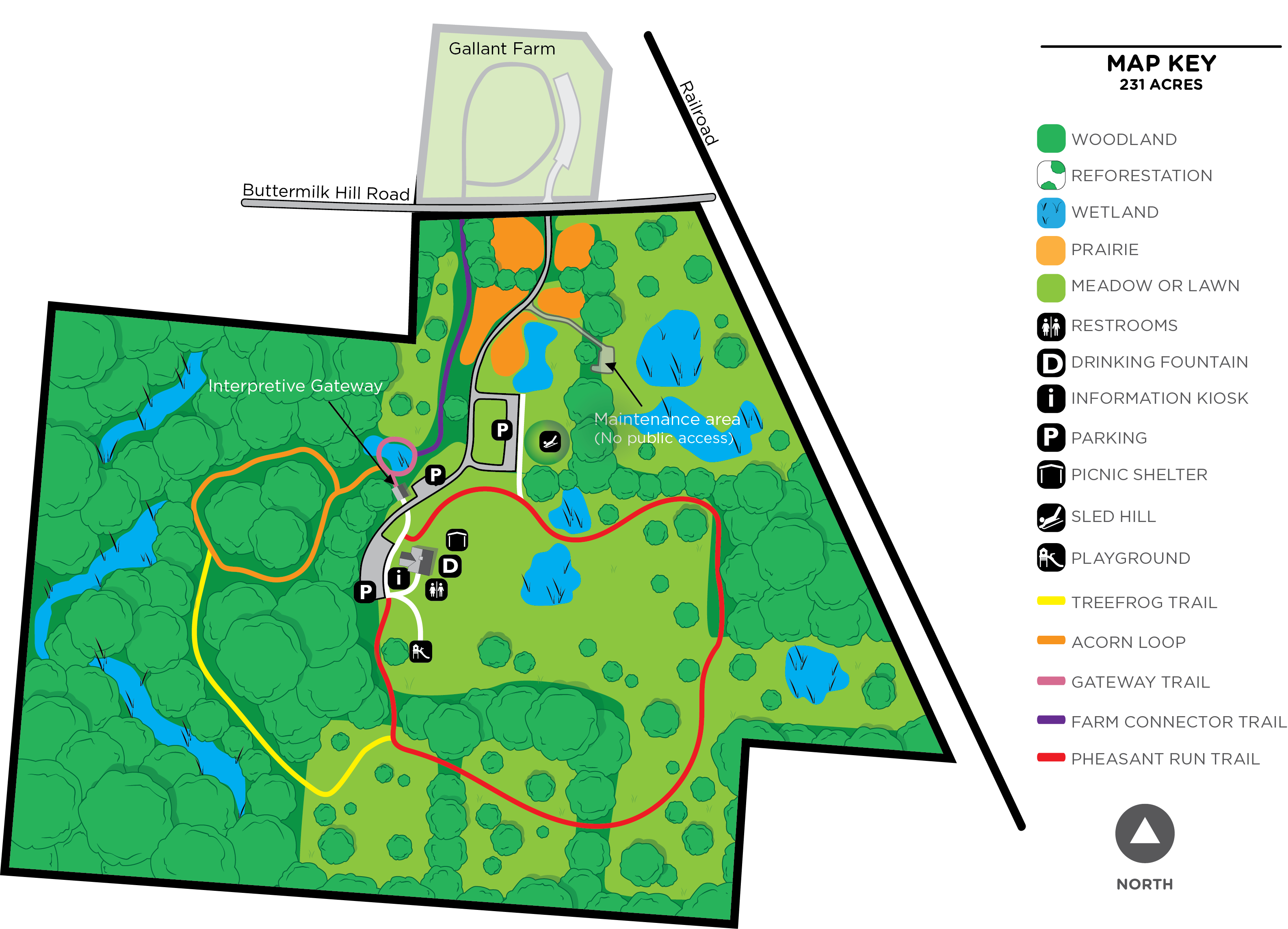
- Gallant Woods Preserve (County Park)
-
- Official Site
- Trail Map
- Posts at TrekOhio
- Location:
- 2151 Buttermilk Hill Road, Delaware, Ohio 43015
- GPS coordinates: 40.3454564, -83.118826
- View on Google Maps
- 231 acres in all
- 3.35 miles of total trail
- Supported activities:
- Sledding
- Good site for bird watching
- Bringing your dog
- Genoa Township Bike Trail (Bike Path)
-
- Official Site
- Trail Map
- McNamara Park, entrance off of S. Old 3C Rd.:
- GPS coordinates: 40.182475, -82.9020193
- View on Google Maps
- McNamara Park, entrance off of Big Walnut Road:
- 7049 Big Walnut Rd., Galena, Ohio 43021
- GPS coordinates: 40.179794, -82.911233
- View on Google Maps
- About 4 miles of paved, multi-use trail
- Supported activities:
- Bringing your dog
- Miscellaneous info: Extends from Mt. Royal Ave. (just north of Krogers near State Route 3 and Maxtown) northward to Plumb Rd.
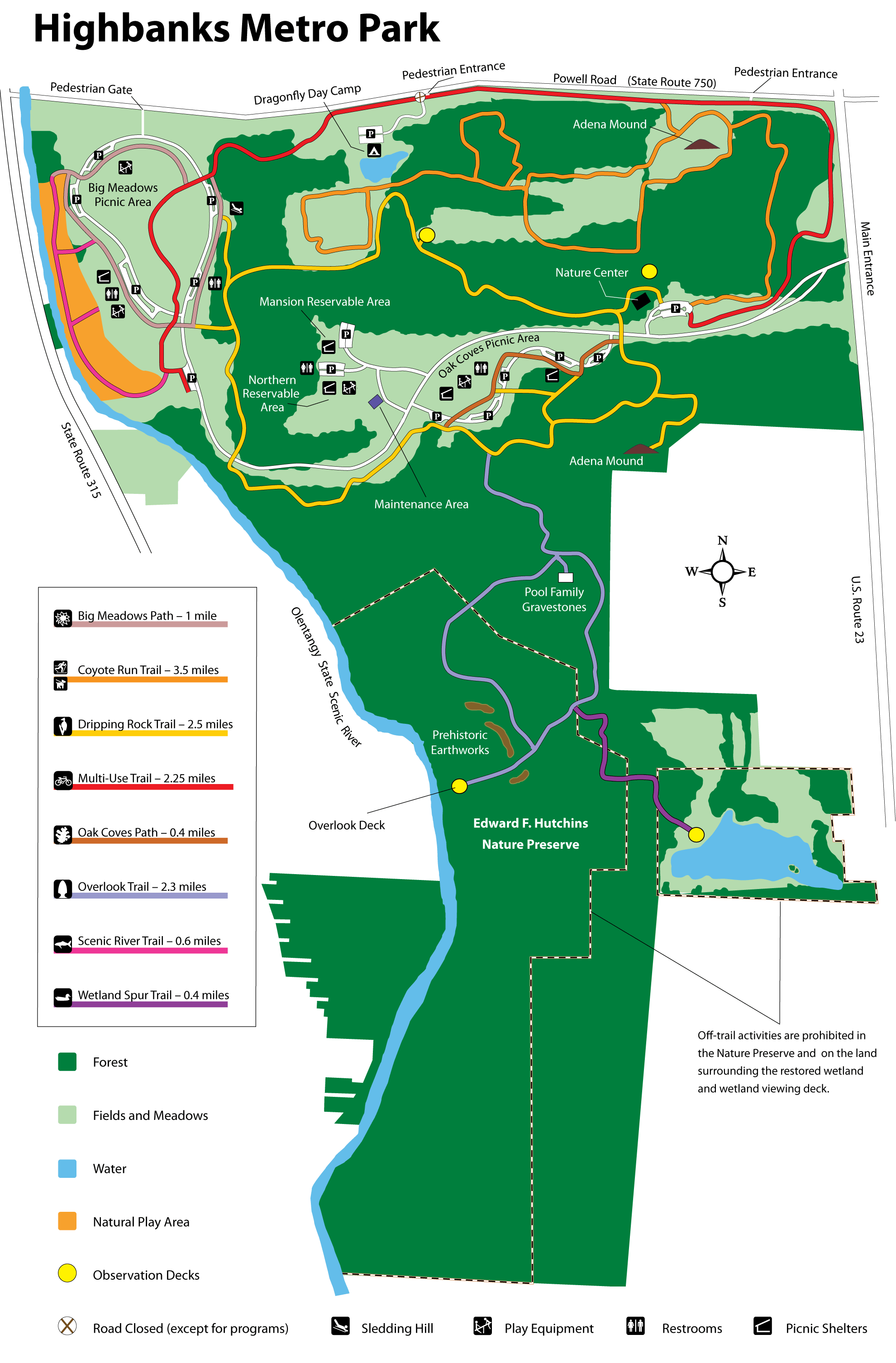
- Highbanks (Metro Park)
-
- Official Site
- Trail Map
- Trail descriptions
- Posts at TrekOhio
- Main Entrance:
- 9466 Columbus Pike (US Rt 23 N), Lewis Center, Ohio 43035
- GPS coordinates: 40.1320893, -83.0062937
- View on Google Maps
- Dragonfly Day Camp:
- 685 W. Powell Road, Lewis Center, Ohio 43065
- GPS coordinates: 40.1559129, -83.0370941
- View on Google Maps
- River Bluff area:
- 8400 Olentangy River Road, Columbus, Ohio 43235
- GPS coordinates: 40.1370306, -83.0392638
- View on Google Maps
- 1,200 acre in all
- Trail information:
- 3.7 miles of paved trails
- 6.1 miles of gravel trails
- 3.9 miles of grass and dirt trails
- Supported activities:
- Fishing
- Cross-country skiing
- Sledding
- Good site for bird watching
- Bringing your dog
- Paddling
- Facilities:
- Restroom facilities
- Handicap accessible
- Nature center
- Miscellaneous info: 15-acre area dedicated to natural play; paddling access to the Olentangy River at the River Bluff area.
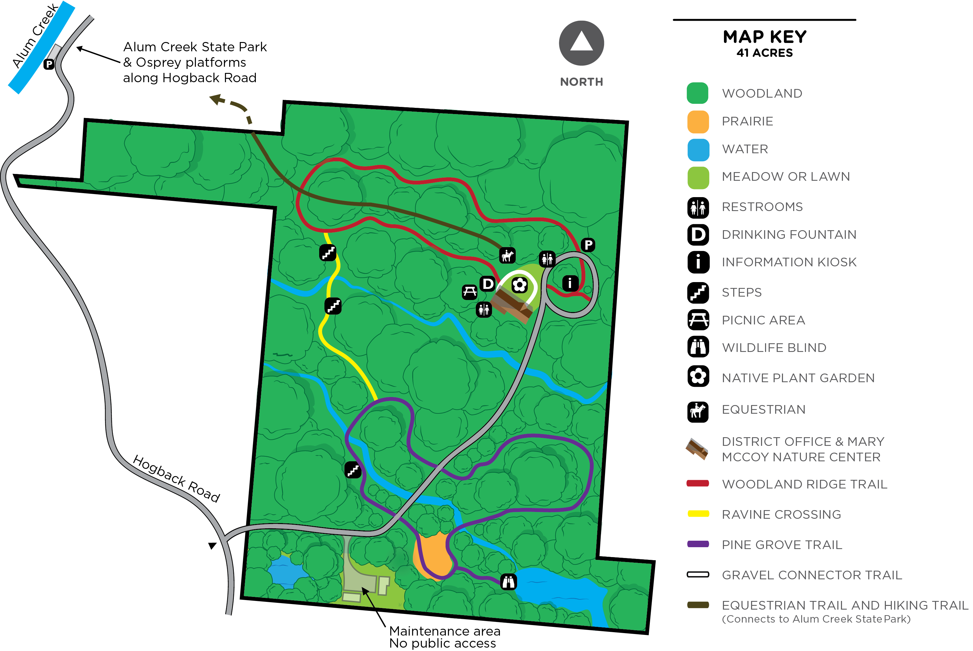
- Hogback Ridge Preserve (County Park)
-
- Official Site
- Trail Map
- Location:
- 2656 Hogback Road, Sunbury, Ohio 43074
- GPS coordinates: 40.30948, -82.9437156
- View on Google Maps
- 41 acres in all
- Trail information:
- 0.8 miles of hiking trails
- Unspecified mileage of bridle trail
- Supported activities:
- Good site for bird watching
- Bringing your dog
- Facilities:
- Nature center
- Miscellaneous info: The bridle trail connects with the bridle trails in Alum Creek State Park. Although you cannot park your horse trailer in Hogback Ridge Park, you can ride into the park from the state park and tie your horse at Hogback Ridge while you explore the county park.
- Hoover Reservoir (Columbus City Nature Preserve)
-
- Official Site
- Posts at TrekOhio
- Mud Hen Marsh
- Disc Golf
- Park Area near the Dam:
- 7701 Sunbury Rd., Westerville, Ohio 43081
- GPS coordinates: 40.1080139, -82.8863823
- View on Google Maps
- Brent Hambrick Memorial Disc Golf Course:
- 2000 Central College Rd., Westerville, Ohio 43081
- GPS coordinates: 40.1040154, -82.8859063
- View on Google Maps
- Hoover Mudflats Boardwalk:
- West St. & Front St., Galena, Ohio 43021
- GPS coordinates: 40.213776, -82.88026
- View on Google Maps
- Hoover Meadows:
- Sunbury Road, Galena, Ohio 43021
- GPS coordinates: 40.193086, -82.871976
- View on Google Maps
- Mud Hen Marsh:
- 8472 Big Walnut Rd., Westerville, Ohio 43082
- GPS coordinates: 40.1713716, -82.8831306
- View on Google Maps
- About 4,700 acres in all
- Supported activities:
- Fishing
- Good site for bird watching
- Low-horsepower boating (depending on the park, this may mean boats with electric motors, boats whose motors do not exceed a specific horsepower, or boats with any horsepower motor as long as no wake is generated; check the official site for details)
- Facilities:
- Restroom facilities
- Disc golf course
- Boardwalk
- Miscellaneous info: There are multiple recreational locations around Hoover Reservoir. Hoover Mudflats has 1,500 ft boardwalk.
- Hutchins (State Nature Preserve)
-
- Official Site
- 206 acres in all
- Miscellaneous info: Entirely contained within Highbanks Metro Park. Includes the 100-foot high bluffs overlooking the Olentangy State Scenic River and the semi-circular earthwork attributed to Native Americans referred to as the Late Woodland people (Cole culture).
- Olentangy Indian Caverns (Private Cavern)
-
- Official Site
- Location:
- 1779 Home Road, Delaware, Ohio 43015
- Facilities:
- Restroom facilities
- Seymour Woods (State Nature Preserve)
-
- Official Site
- Posts at TrekOhio
- Location:
- 438 Township Hwy 98, Delaware, Ohio 43015
- GPS coordinates: 40.22799, -83.05490
- View on Google Maps
- 115 acres in all
- Shale Hollow Preserve (County Park)
-
- Official Site
- Trail Map
- Posts at TrekOhio
- Location:
- 6320 Artesian Run, Lewis Center, Ohio 43035
- GPS coordinates: 40.212998548, -83.03476619
- View on Google Maps
- 211 acres in all
- 2.1 miles of walking trails
- Supported activities:
- Bringing your dog
- Facilities:
- Restroom facilities
- Miscellaneous info: Shale cliffs, wildflowers. Off-trail exploration of the flood plain area is allowed, but no dogs in this area. A building on site is available for rental for business meetings.
- Stratford Woods (State Nature Preserve)
-
- Official Site
- Posts at TrekOhio
- Location:
- 3083 Liberty Road, Delaware, Ohio 43015
- GPS coordinates: 40.257193, -83.074322
- View on Google Maps
- 236 acres in all
- 4 miles of nature trails
- Miscellaneous info: Please sign in at visitors center when you arrive. The site features a working farm; farm products are available for sale based on season. A variety of educational programs and festivals are held.
_email.jpg)
Last Update: Jun 20, 2018
© Deborah Platt, Robert Platt and TrekOhio.com 2012 to 2021