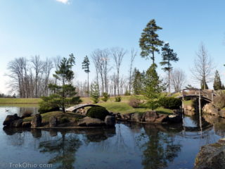
 Dawes Arboretum located in Central Ohio consists of 1,800 acres of formal gardens, fields, ponds, and forests, including eight miles of hiking trails. Among its facilities are a visitors center, rest rooms, picnic areas and shelters. The meticulously maintained formal gardens are a popular venue for weddings.
The arboretum was established by Columbus residents Beman and Bertie Dawes. They purchased an old farm in Licking County, renamed it Daweswood and planted trees and established gardens. Read more ➜
Dawes Arboretum located in Central Ohio consists of 1,800 acres of formal gardens, fields, ponds, and forests, including eight miles of hiking trails. Among its facilities are a visitors center, rest rooms, picnic areas and shelters. The meticulously maintained formal gardens are a popular venue for weddings.
The arboretum was established by Columbus residents Beman and Bertie Dawes. They purchased an old farm in Licking County, renamed it Daweswood and planted trees and established gardens. Read more ➜ Dawes Arboretum
Dawes Arboretum located in Central Ohio consists of 1,800 acres of formal gardens, fields, ponds, and forests, including eight miles of hiking trails. Among its facilities are a visitors center, rest rooms, picnic areas and shelters. The meticulously maintained formal gardens are a popular venue for weddings.
The arboretum was established by Columbus residents Beman and Bertie Dawes. They purchased an old farm in Licking County, renamed it Daweswood and planted trees and established gardens. Read more ➜ 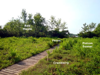 Previously I've pointed out that Jackson Bog and Cedar Bog aren't really bogs. Now it's time to look at a nature preserve that really is the bog that it claims to be: Cranberry Bog State Nature Preserve. However it's not like any other bog in the world since the entire bog is floating in the middle of a lake.
Here's what happened. For thousands of years Cranberry Bog was an ordinary bog located in what came to be known as Big Swamp. In 1830 Ohio decided to build a dyke in Big Swamp
Previously I've pointed out that Jackson Bog and Cedar Bog aren't really bogs. Now it's time to look at a nature preserve that really is the bog that it claims to be: Cranberry Bog State Nature Preserve. However it's not like any other bog in the world since the entire bog is floating in the middle of a lake.
Here's what happened. For thousands of years Cranberry Bog was an ordinary bog located in what came to be known as Big Swamp. In 1830 Ohio decided to build a dyke in Big Swamp  Overview
The Newark Earthworks were constructed about 2000 years ago by the prehistoric, Hopewell people. These are the largest, geometric earthworks in the world. To give you a better sense of the size and shape of these structures, it's best to look at an aerial view. Since I can't take aerial photos myself, I photographed some of the interpretive signs near the earthworks.
The plaque below shows the layout of the Newark Earthworks which occupy four square miles (10.6 square kilometers).
I
Overview
The Newark Earthworks were constructed about 2000 years ago by the prehistoric, Hopewell people. These are the largest, geometric earthworks in the world. To give you a better sense of the size and shape of these structures, it's best to look at an aerial view. Since I can't take aerial photos myself, I photographed some of the interpretive signs near the earthworks.
The plaque below shows the layout of the Newark Earthworks which occupy four square miles (10.6 square kilometers).
I 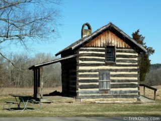 There are three different trail groupings at Blackhand Gorge State Nature Preserve, but for the longest time we only knew of the main parking lot and the trail head that leads off from there. So at the end of this post there's a map and directions showing the location of them all. The icon used to locate the feature on the map is described in parentheses after each heading.
Blackhand Trail, Quarry Rim Trail & Chestnut Trail(Cabin Icon)
There is an old log cabin at the main parking lot across
There are three different trail groupings at Blackhand Gorge State Nature Preserve, but for the longest time we only knew of the main parking lot and the trail head that leads off from there. So at the end of this post there's a map and directions showing the location of them all. The icon used to locate the feature on the map is described in parentheses after each heading.
Blackhand Trail, Quarry Rim Trail & Chestnut Trail(Cabin Icon)
There is an old log cabin at the main parking lot across 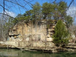 By visiting Blackhand Gorge Nature Preserve, you can trace Ohio's long history of transportation.
Native Americans navigated the Licking River for centuries before the arrival of European settlers. There is a cliff made of Blackhand sandstone rising on the north side of the Licking River. In prehistoric times, Native Americans inscribed a petroglyph on this cliff; it looked like a very large, black hand. Not only is the gorge named after this petroglyph, but the class of erosion-resistant sandstone
By visiting Blackhand Gorge Nature Preserve, you can trace Ohio's long history of transportation.
Native Americans navigated the Licking River for centuries before the arrival of European settlers. There is a cliff made of Blackhand sandstone rising on the north side of the Licking River. In prehistoric times, Native Americans inscribed a petroglyph on this cliff; it looked like a very large, black hand. Not only is the gorge named after this petroglyph, but the class of erosion-resistant sandstone 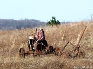 These scarecrows are part of a display at Dawes Arboretum that explores alternative energy, such as producing fuel from switch grass. However they appear here because I think scarecrows are adorable. I also like rusty relics, so I particularly liked the scarecrow on the tractor.
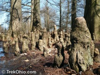 I always associated the bald-cypress pictured above with the bayous of the deep south. Imagine my surprise to learn that we have some growing in Central Ohio. It turns out that the mature bald-cypress (Taxodium distichum) is actually cold tolerant. You may be wondering why we aren't seeing them all over the place. Well, they can't reproduce naturally in this climate because the immature seedlings are susceptible to ice damage. But if you nurture the little seedlings in a greenhouse, then transplant