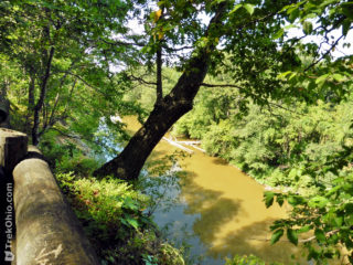
 After stopping at a rest area while traveling westbound on OH-2, we were surprised to see a sign announcing a "Scenic Overlook."
Near the sign a paved trail led through the woods. Once we entered the trailhead, we soon realized this was a short, loop trail. There were benches located periodically along the trail.
The fence extended along the cliff's edge for some ways, so there were a number of opportunities to look at the Vermilion River below. While viewing the river, Read more ➜
After stopping at a rest area while traveling westbound on OH-2, we were surprised to see a sign announcing a "Scenic Overlook."
Near the sign a paved trail led through the woods. Once we entered the trailhead, we soon realized this was a short, loop trail. There were benches located periodically along the trail.
The fence extended along the cliff's edge for some ways, so there were a number of opportunities to look at the Vermilion River below. While viewing the river, Read more ➜ Vermilion River Scenic Overlook at OH-2 Rest Area
After stopping at a rest area while traveling westbound on OH-2, we were surprised to see a sign announcing a "Scenic Overlook."
Near the sign a paved trail led through the woods. Once we entered the trailhead, we soon realized this was a short, loop trail. There were benches located periodically along the trail.
The fence extended along the cliff's edge for some ways, so there were a number of opportunities to look at the Vermilion River below. While viewing the river, Read more ➜ 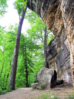 The Ledge Trail is located in the Virginia Kendall Unit of the Cuyahoga Valley National Park. The trail follows along the sandstone cliffs that make up Ritchie Ledges. The trail map at the kiosk says that the Ledges trail is a 1.8-mile loop. However, I have seen numerous other sites on the web say the trail is 2.2 miles. According to park officials it is a moderately difficult trail to hike. If the loop isn't enough of a work-out, there are connector trails leading to other, nearby trails, so you
 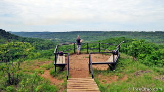 Buzzardroost Rock Trail offers a truly stunning vista perched 500 feet above the Ohio Brush Creek valley. The trail is part of the 16,000-acre Edge of Appalachia Preserve in Adams County. Located just south of Ohio SR-125, the trail stretches 2.2 miles one-way along ridgelines from the parking lot to the observation area, making for a 4.4 mile hike.
A sign at a gravel turn-off on the south side of SR-125 identifies the parking area and trail-head for Buzzardroost Trail. About a quarter
Buzzardroost Rock Trail offers a truly stunning vista perched 500 feet above the Ohio Brush Creek valley. The trail is part of the 16,000-acre Edge of Appalachia Preserve in Adams County. Located just south of Ohio SR-125, the trail stretches 2.2 miles one-way along ridgelines from the parking lot to the observation area, making for a 4.4 mile hike.
A sign at a gravel turn-off on the south side of SR-125 identifies the parking area and trail-head for Buzzardroost Trail. About a quarter 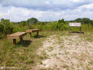 Last weekend after hiking at Wildcat Hollow, we drove over to have a look at Monroe Outlook. Monroe Outlook is a scenic overlook providing a large hill-top panoramic view of the area. The site was developed by Wayne National Forest, Ohio Dept. of Natural Resources, Little Cities of the Forest Collaboration, and Miller High School.
The parking area is a small gravel parking lot with an informational kiosk off of Irish Ridge Road. Its about a 5 minute drive from the Wildcat Hollow trail-head.
Last weekend after hiking at Wildcat Hollow, we drove over to have a look at Monroe Outlook. Monroe Outlook is a scenic overlook providing a large hill-top panoramic view of the area. The site was developed by Wayne National Forest, Ohio Dept. of Natural Resources, Little Cities of the Forest Collaboration, and Miller High School.
The parking area is a small gravel parking lot with an informational kiosk off of Irish Ridge Road. Its about a 5 minute drive from the Wildcat Hollow trail-head. 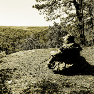 Have you enjoyed the thrill of standing in a high place surveying the landscape far below? It's a bit of a challenge to find such places in a natural setting in Ohio, but not impossible. Below is a list of scenic overlooks or vistas that Deb and I have enjoyed along with links to their location and some notes.
Its not possible to simply look at a topographic map and find good scenic overlooks. As Ohio doesn't have mountains, a hilltop may potentially offer a vista but be so heavily forested
Have you enjoyed the thrill of standing in a high place surveying the landscape far below? It's a bit of a challenge to find such places in a natural setting in Ohio, but not impossible. Below is a list of scenic overlooks or vistas that Deb and I have enjoyed along with links to their location and some notes.
Its not possible to simply look at a topographic map and find good scenic overlooks. As Ohio doesn't have mountains, a hilltop may potentially offer a vista but be so heavily forested  This fall Bob and I visited Rising Park in Lancaster, Ohio. The big attraction there is the view from the top of Mount Pleasant. Both of us wanted to see what the view would look like when blanketed in snow, so we went back to take some more photos a week or so ago.
If you look at the top photo you'll see that I was standing behind a safety rail. It was disheartening to see that there were tracks in the snow up to the edge of the cliff. Especially considering
This fall Bob and I visited Rising Park in Lancaster, Ohio. The big attraction there is the view from the top of Mount Pleasant. Both of us wanted to see what the view would look like when blanketed in snow, so we went back to take some more photos a week or so ago.
If you look at the top photo you'll see that I was standing behind a safety rail. It was disheartening to see that there were tracks in the snow up to the edge of the cliff. Especially considering 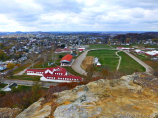 Lancaster, Ohio has a population just under 39,000, and it is the county seat of Fairfield County. It has a municipal park known as "Rising Park." The park offers the normal sort of amenities that you might expect: a pond, picnic tables, playgrounds... things of that nature. But what's unusual about the park is its terrain. Rising 250-foot (76 m) above the surrounding plain is a bluff known as "Mount Pleasant." The bluff is made of highly erosion-resistant Blackhand sandstone. From the top of Mount