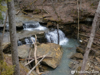
 We visited John and Marion Becker Cedar Falls Preserve in the late summer of 2020 and early spring of 2021. This Adams County preserve is owned by the Edge of Appalachia and was opened recently. The star attraction of the preserve is a fifteen foot waterfall named Cedar Falls - not to be confused with the other Cedar Falls located in Hocking County.
When visiting Scioto and Adams County, we frequently stay at Shawnee Lodge in Shawnee State Park. The trailhead for the preserve is a half-hour drive Read more ➜
We visited John and Marion Becker Cedar Falls Preserve in the late summer of 2020 and early spring of 2021. This Adams County preserve is owned by the Edge of Appalachia and was opened recently. The star attraction of the preserve is a fifteen foot waterfall named Cedar Falls - not to be confused with the other Cedar Falls located in Hocking County.
When visiting Scioto and Adams County, we frequently stay at Shawnee Lodge in Shawnee State Park. The trailhead for the preserve is a half-hour drive Read more ➜ John and Marion Becker Cedar Falls Preserve
We visited John and Marion Becker Cedar Falls Preserve in the late summer of 2020 and early spring of 2021. This Adams County preserve is owned by the Edge of Appalachia and was opened recently. The star attraction of the preserve is a fifteen foot waterfall named Cedar Falls - not to be confused with the other Cedar Falls located in Hocking County.
When visiting Scioto and Adams County, we frequently stay at Shawnee Lodge in Shawnee State Park. The trailhead for the preserve is a half-hour drive Read more ➜ 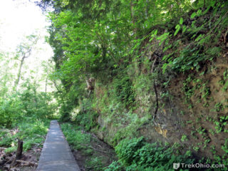 Davis Memorial State Nature Preserve is one of the more interesting geological sites in Ohio. There are six fault lines in Adams County. Surprisingly, one of these fault lines is visible within the preserve. In addition Adams County is one of the few places in Ohio where you can observe rock outcroppings made of dolomite (sometimes called dolostone). Dolomite and limestone are both said to be calcareous due to their high calcium content, and both are alkaline. They even resemble each other visually.
 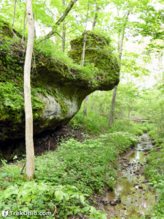 Chalet Nivale Preseve is a 106-acre preserve in Adams County that is owned and managed by the non-profit organization, the Arc of Appalachia. The preserve contains two feeder streams that are part of the Scioto Brush Creek Watershed; these feeder streams are among the highest water quality streams in the state of Ohio. By protecting the woodlands around these feeder streams, their exceptional water quality goes on to enhance the water quality of Scioto Brush Creek.
Recreational hikers have three
Chalet Nivale Preseve is a 106-acre preserve in Adams County that is owned and managed by the non-profit organization, the Arc of Appalachia. The preserve contains two feeder streams that are part of the Scioto Brush Creek Watershed; these feeder streams are among the highest water quality streams in the state of Ohio. By protecting the woodlands around these feeder streams, their exceptional water quality goes on to enhance the water quality of Scioto Brush Creek.
Recreational hikers have three 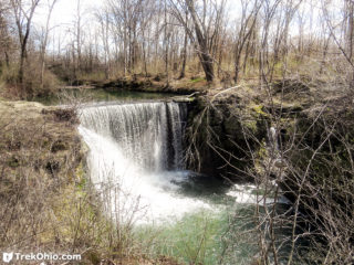 Indian Mound Reserve is a 169-acre park that's managed by the Greene County park district. We were very favorably impressed by the park's historic and natural features. Among the historic features are:
Williamson Mound: a Native American, earthen mound constructed by the Adena culture between 500 B.C. and 100 A.D.
Pollock Works: a Native American, earthen wall constructed by the Hopewell culture between 100 B.C. and 500 A.D.
A historic log cabin that's currently being renovated
A dam created
Indian Mound Reserve is a 169-acre park that's managed by the Greene County park district. We were very favorably impressed by the park's historic and natural features. Among the historic features are:
Williamson Mound: a Native American, earthen mound constructed by the Adena culture between 500 B.C. and 100 A.D.
Pollock Works: a Native American, earthen wall constructed by the Hopewell culture between 100 B.C. and 500 A.D.
A historic log cabin that's currently being renovated
A dam created 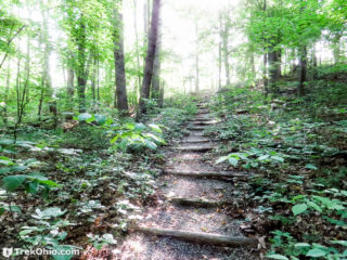 Towards the end of last spring we visited the Wilderness Trail at the Edge of Appalachia Preserve in Adams County. Starting at the parking area, the trail is a 2.4 mile loop. The trail features hills, rock outcroppings, streams, forest with lush vegetation, and a small segment of prairie.
Getting Oriented
We hiked the trail in a counter-clockwise direction, passing through the prairie opening towards the end.
The Hike
The parking lot is at the end of Shivener Rd, a gravel
Towards the end of last spring we visited the Wilderness Trail at the Edge of Appalachia Preserve in Adams County. Starting at the parking area, the trail is a 2.4 mile loop. The trail features hills, rock outcroppings, streams, forest with lush vegetation, and a small segment of prairie.
Getting Oriented
We hiked the trail in a counter-clockwise direction, passing through the prairie opening towards the end.
The Hike
The parking lot is at the end of Shivener Rd, a gravel 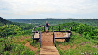 Buzzardroost Rock Trail offers a truly stunning vista perched 500 feet above the Ohio Brush Creek valley. The trail is part of the 16,000-acre Edge of Appalachia Preserve in Adams County. Located just south of Ohio SR-125, the trail stretches 2.2 miles one-way along ridgelines from the parking lot to the observation area, making for a 4.4 mile hike.
A sign at a gravel turn-off on the south side of SR-125 identifies the parking area and trail-head for Buzzardroost Trail. About a quarter
Buzzardroost Rock Trail offers a truly stunning vista perched 500 feet above the Ohio Brush Creek valley. The trail is part of the 16,000-acre Edge of Appalachia Preserve in Adams County. Located just south of Ohio SR-125, the trail stretches 2.2 miles one-way along ridgelines from the parking lot to the observation area, making for a 4.4 mile hike.
A sign at a gravel turn-off on the south side of SR-125 identifies the parking area and trail-head for Buzzardroost Trail. About a quarter 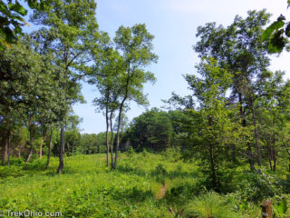 The Richard and Lucile Durrell Edge of Appalachia Preserve is situated 75 miles south of Cincinnati. The preserve system is managed jointly by the Museum of Cincinnati and the Nature Conservancy. Together its eleven different properties preserve some 16,000 acres of the western edge of the Appalachian Escarpment. Currently four of these properties feature hiking trails. We previously described the Joan Jones Portman Trail. Today we'll describe a hike we took mid-July on the Lynx Prairie Trail.
There
The Richard and Lucile Durrell Edge of Appalachia Preserve is situated 75 miles south of Cincinnati. The preserve system is managed jointly by the Museum of Cincinnati and the Nature Conservancy. Together its eleven different properties preserve some 16,000 acres of the western edge of the Appalachian Escarpment. Currently four of these properties feature hiking trails. We previously described the Joan Jones Portman Trail. Today we'll describe a hike we took mid-July on the Lynx Prairie Trail.
There 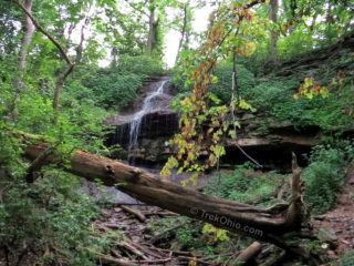 We visited the 1,900 acre Englewood Metropark in the Dayton area during the summer to hike and view three small waterfalls. Englewood is located just northwest of Dayton near Dayton Airport. It is part of Montgomery County's Five Rivers MetroParks. The park is named for the Englewood dam on the Stillwater River which flows through the park. The lake created by the dam is known as the Englewood Recreation Reservoirm.
Englewood offers a variety of recreational activities including fishing,
We visited the 1,900 acre Englewood Metropark in the Dayton area during the summer to hike and view three small waterfalls. Englewood is located just northwest of Dayton near Dayton Airport. It is part of Montgomery County's Five Rivers MetroParks. The park is named for the Englewood dam on the Stillwater River which flows through the park. The lake created by the dam is known as the Englewood Recreation Reservoirm.
Englewood offers a variety of recreational activities including fishing, 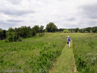 Chaparral Prairie is a 67-acres state nature preserve with a three-quarter mile loop trail. Located in Adams County, it preserves a rare prairie habitat. Prairies are defined by the type of vegetation that grows in them. In general these plants are drought-tolerant, fire-tolerant and shade-intolerant. They originated in America's Great Plains and moved eastward thousands of years ago during a centuries-long drought when this area was warmer than now. However as the climate cooled and normal rain
 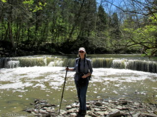 In April we drove to Caesar Creek State Park to visit a new pedestrian suspension bridge and two waterfalls. Our hikes consisted of two segments on the southern portion of the Perimeter Loop Trail. The yellow-blazed Perimeter Loop Trail is an 11.5 mile loop trail on either side of Caesar Creek Lake. The northern and southern routes are connected by a bridge on one end and Caesar Creek Dam on the other.
Our first hike started at the Flat Fork Ridge Recreation Area located on Clarksville
In April we drove to Caesar Creek State Park to visit a new pedestrian suspension bridge and two waterfalls. Our hikes consisted of two segments on the southern portion of the Perimeter Loop Trail. The yellow-blazed Perimeter Loop Trail is an 11.5 mile loop trail on either side of Caesar Creek Lake. The northern and southern routes are connected by a bridge on one end and Caesar Creek Dam on the other.
Our first hike started at the Flat Fork Ridge Recreation Area located on Clarksville