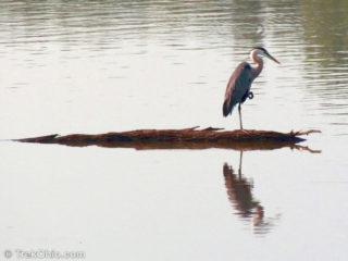
 One of our favorite locales for bird watching is Hoover Mudflats Boardwalk. We've previously posted about it here. This locale is constantly changing with the season and the level of Hoover reservoir, but it rarely disappoints.
Hoover reservoir is purposely lowered every fall to create a way station for migrating shore birds. But due to the drought, the water level has dropped earlier than usual. When summer began the boardwalk was several feet above the water's surface. Last month the Read more ➜
One of our favorite locales for bird watching is Hoover Mudflats Boardwalk. We've previously posted about it here. This locale is constantly changing with the season and the level of Hoover reservoir, but it rarely disappoints.
Hoover reservoir is purposely lowered every fall to create a way station for migrating shore birds. But due to the drought, the water level has dropped earlier than usual. When summer began the boardwalk was several feet above the water's surface. Last month the Read more ➜ Morning at Hoover Mudflats Boardwalk
One of our favorite locales for bird watching is Hoover Mudflats Boardwalk. We've previously posted about it here. This locale is constantly changing with the season and the level of Hoover reservoir, but it rarely disappoints.
Hoover reservoir is purposely lowered every fall to create a way station for migrating shore birds. But due to the drought, the water level has dropped earlier than usual. When summer began the boardwalk was several feet above the water's surface. Last month the Read more ➜ 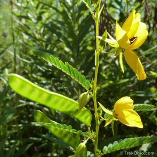 While I was at Gahanna Woods, I spotted these partridge peas growing in the meadow. They are native to the eastern United States, growing up to 3 feet (1 meter) tall. Their leaves are compound with each leaf having five to eighteen pairs of leaflets. Although I have heard of flowers that fold up their blossoms at night, the partridge pea is somewhat different in that it folds up its leaves at night. Each of the plant's yellow flowers has five petals with the bottom petal being longer than
 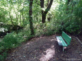 Gahanna Woods is part city park and part state nature preserve. Let's start by looking at the city park.
Gahanna Woods City Park
The city park has trails that pass through meadow and woodlands. The meadow trail is a mown path; The woodland trail is a wide trail with a mulch base that often follows a small creek. The city seems to be expanding their trail system, especially the mown paths. I encountered more trail branches than the map in the kiosk showed. A few branches off the
Gahanna Woods is part city park and part state nature preserve. Let's start by looking at the city park.
Gahanna Woods City Park
The city park has trails that pass through meadow and woodlands. The meadow trail is a mown path; The woodland trail is a wide trail with a mulch base that often follows a small creek. The city seems to be expanding their trail system, especially the mown paths. I encountered more trail branches than the map in the kiosk showed. A few branches off the 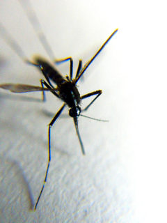 Photo courtesy of tanakawho, license: CC BY 2.0
Mosquito
Outbreak of 2012
According to the Center for Disease Control (CDC) as of August 21st, nearly 1118 people have become ill from the West Nile Virus this summer; 41 have died from the most severe form of this illness. This is biggest outbreak since 2004. Since the virus is transmitted by mosquito bites, the high incidence of the disease is attributed to an unusually large number of mosquitoes. More mosquitoes than usual survived over
Photo courtesy of tanakawho, license: CC BY 2.0
Mosquito
Outbreak of 2012
According to the Center for Disease Control (CDC) as of August 21st, nearly 1118 people have become ill from the West Nile Virus this summer; 41 have died from the most severe form of this illness. This is biggest outbreak since 2004. Since the virus is transmitted by mosquito bites, the high incidence of the disease is attributed to an unusually large number of mosquitoes. More mosquitoes than usual survived over 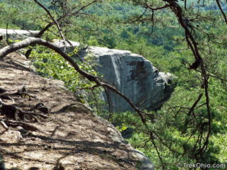 It was a sunny Sunday afternoon. We stood on top of a rock outcropping shaped like an airplane overlooking Crane Hollow far below. From our vantage point, we had a magnificent view of the forest valley and hillsides miles away.
The outcropping is known as Airplane Rock. The trailhead leading to Airplane Rock is just up the road from Conkles Hollow State Nature Preserve. The trail itself is a bridle trail which hikers are allowed to share. Surprisingly there is no signage that might
It was a sunny Sunday afternoon. We stood on top of a rock outcropping shaped like an airplane overlooking Crane Hollow far below. From our vantage point, we had a magnificent view of the forest valley and hillsides miles away.
The outcropping is known as Airplane Rock. The trailhead leading to Airplane Rock is just up the road from Conkles Hollow State Nature Preserve. The trail itself is a bridle trail which hikers are allowed to share. Surprisingly there is no signage that might 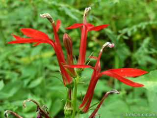 Thayer Ridge Park features a picnic area (without restrooms), a frisbee disc golf course, and some multi-use, dirt trails going through woodland and meadows. The trails are open to horseback riders, mountain bikers and hikers. I have hiked there twice (in April and in August); in my opinion the trails are probably best suited for those on horseback.
On each of my two visits it was clear that the trails were being used regularly by riders. Here's why I think the trail conditions are
Thayer Ridge Park features a picnic area (without restrooms), a frisbee disc golf course, and some multi-use, dirt trails going through woodland and meadows. The trails are open to horseback riders, mountain bikers and hikers. I have hiked there twice (in April and in August); in my opinion the trails are probably best suited for those on horseback.
On each of my two visits it was clear that the trails were being used regularly by riders. Here's why I think the trail conditions are 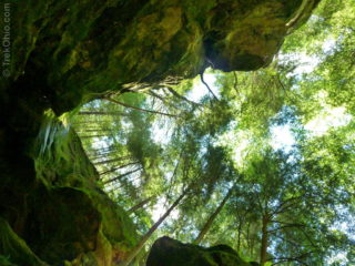 Conkle's Hollow is a narrow gorge with breathtaking cliffs rising on either side; the cliffs are made of Blackhand sandstone and are quite sheer in places, the taller ones reaching up to 200 feet in height. Seasonal waterfalls flow from the cliffs at many sites, their streams joining to form Pine Creek on the valley floor.
Conkle's Hollow State Nature Preserve has two main trails. The Rim Trail is on the plateau above and leads you around the upper border of the gorge.
Conkle's Hollow is a narrow gorge with breathtaking cliffs rising on either side; the cliffs are made of Blackhand sandstone and are quite sheer in places, the taller ones reaching up to 200 feet in height. Seasonal waterfalls flow from the cliffs at many sites, their streams joining to form Pine Creek on the valley floor.
Conkle's Hollow State Nature Preserve has two main trails. The Rim Trail is on the plateau above and leads you around the upper border of the gorge. 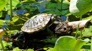 I was really surprised when I saw the turtle pictured above. First, this species of turtle, a Red-eared Slider, is not known to occur in the wild in Franklin County. Second, what on earth is wrong with its shell? Let's look at it more closely.
The turtle's shell is subdivided into sections called scutes. In my photo there is a front scute that's a lighter color, almost a light brown, toward the front of the shell. It seems to be raised above the surrounding scutes. Toward the
I was really surprised when I saw the turtle pictured above. First, this species of turtle, a Red-eared Slider, is not known to occur in the wild in Franklin County. Second, what on earth is wrong with its shell? Let's look at it more closely.
The turtle's shell is subdivided into sections called scutes. In my photo there is a front scute that's a lighter color, almost a light brown, toward the front of the shell. It seems to be raised above the surrounding scutes. Toward the 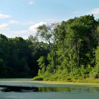 Char-Mar Ridge is part of Delaware County's preservation park system. It features a wooded trail that passes over gently rolling hills. The trail itself is packed earth and gravel that remains in good condition even when it's rainy. A 0.25 mile trail connects the parking lot to a loop trail. The loop trail is 1.5 miles and is very popular with joggers who often do multiple laps. Like most of Delaware County's parks, visitors are allowed to bring their leashed dogs along with them. "Mutt mitts" are
 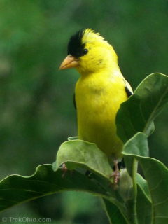 We have bird feeders in our backyard. I like to sit in our breakfast nook reading or working on the computer. Then from time to time I'll lift my head to see what birds are out there now. The feeders are located far enough away from our house to make it unlikely that a bird will strike our windows. But that means that I sometimes resort to using binoculars if I want to get a good look at a particular bird.
My bird watching got a little easier when the goldfinch in the topmost photo
We have bird feeders in our backyard. I like to sit in our breakfast nook reading or working on the computer. Then from time to time I'll lift my head to see what birds are out there now. The feeders are located far enough away from our house to make it unlikely that a bird will strike our windows. But that means that I sometimes resort to using binoculars if I want to get a good look at a particular bird.
My bird watching got a little easier when the goldfinch in the topmost photo