 One feature we often include with our articles is a map of our hike. Originally we used a handheld Magellan Explorist 310 to do the job of mapping our hike. But as we acquired more capable smart phones, we'd switched over to Google's MyTracks application for Android phones. This app had a bit of a learning curve and some idiosyncrasies, but we became accustomed to it and it became our goto application for mapping. We used it for finding our way on the trail (or back to our car) and afterwards to Read more ➜
 GPS Mapping Apps: MyTrails – a Replacement for Google MyTracks
One feature we often include with our articles is a map of our hike. Originally we used a handheld Magellan Explorist 310 to do the job of mapping our hike. But as we acquired more capable smart phones, we'd switched over to Google's MyTracks application for Android phones. This app had a bit of a learning curve and some idiosyncrasies, but we became accustomed to it and it became our goto application for mapping. We used it for finding our way on the trail (or back to our car) and afterwards to Read more ➜ 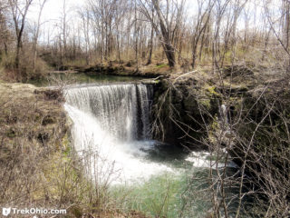 Indian Mound Reserve is a 169-acre park that's managed by the Greene County park district. We were very favorably impressed by the park's historic and natural features. Among the historic features are:
Williamson Mound: a Native American, earthen mound constructed by the Adena culture between 500 B.C. and 100 A.D.
Pollock Works: a Native American, earthen wall constructed by the Hopewell culture between 100 B.C. and 500 A.D.
A historic log cabin that's currently being renovated
A dam created
Indian Mound Reserve is a 169-acre park that's managed by the Greene County park district. We were very favorably impressed by the park's historic and natural features. Among the historic features are:
Williamson Mound: a Native American, earthen mound constructed by the Adena culture between 500 B.C. and 100 A.D.
Pollock Works: a Native American, earthen wall constructed by the Hopewell culture between 100 B.C. and 500 A.D.
A historic log cabin that's currently being renovated
A dam created 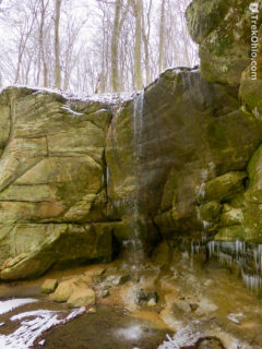 Although we normally aren't free on a weekday, we happened to be at Mohican State Park on Friday, March 4th. We were staying at the lodge for Bob's birthday. Snow had fallen the previous night, so we had our first opportunity to see what Mohican looked like in winter. What a beautiful sight!
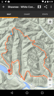
Here is a GPS trace of our hike. We began in the north at Pleasant Hill Dam, traveled south along the westerns side of Clear Fork branch of the Mohican River. After hiking through the Mohican Covered
Although we normally aren't free on a weekday, we happened to be at Mohican State Park on Friday, March 4th. We were staying at the lodge for Bob's birthday. Snow had fallen the previous night, so we had our first opportunity to see what Mohican looked like in winter. What a beautiful sight!
Here is a GPS trace of our hike. We began in the north at Pleasant Hill Dam, traveled south along the westerns side of Clear Fork branch of the Mohican River. After hiking through the Mohican Covered 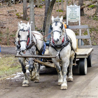 We attended the 40th Annual Malabar Farm Maple Syrup Festival on Saturday March 5th. From the parking area participants queued for a ride by horse drawn wagon to the festival which was centered around the Malabar Farm sugar shack. There were a variety of wagons available for transporting visitors, some with benches and others with hay bales for seating. The wagons were 2HP - each being drawn by two large draft horses. The horses and wagons were provided by volunteers from the Central Ohio Draft Horse
 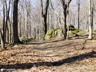 My daughter doesn't like hiking this time of year when there's no snow on the ground and the forests are devoid of greenery. As she puts it, "The forests look like a nuclear wasteland." Although I see her point, there are some advantages to hiking now. If you are considering hiking to some destination where there is no trail (like Trimmer Arch in the Paint Creek Wildlife Area) then going at this time of year means that you will have to contend with the least amount of undergrowth of the year. Similarly
 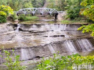 Paine Falls Park is a 377 acre Lake County Metro Park located in Painesville, OH. We visited the park last September.
From the parking area a one tenth mile trail descends a couple of flights of stairs to a viewing area for the waterfall. The park features a restroom and a picnic shelter.
Additional information
Lake County Parks & Preserves — This is the location of Paine Falls; check out this page for links to the official site and for information
Paine Falls Park is a 377 acre Lake County Metro Park located in Painesville, OH. We visited the park last September.
From the parking area a one tenth mile trail descends a couple of flights of stairs to a viewing area for the waterfall. The park features a restroom and a picnic shelter.
Additional information
Lake County Parks & Preserves — This is the location of Paine Falls; check out this page for links to the official site and for information 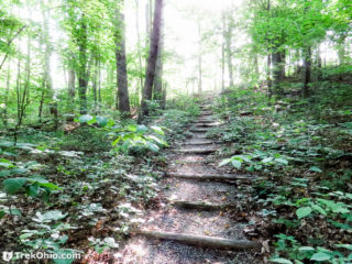 Towards the end of last spring we visited the Wilderness Trail at the Edge of Appalachia Preserve in Adams County. Starting at the parking area, the trail is a 2.4 mile loop. The trail features hills, rock outcroppings, streams, forest with lush vegetation, and a small segment of prairie.
Getting Oriented
We hiked the trail in a counter-clockwise direction, passing through the prairie opening towards the end.
The Hike
The parking lot is at the end of Shivener Rd, a gravel
Towards the end of last spring we visited the Wilderness Trail at the Edge of Appalachia Preserve in Adams County. Starting at the parking area, the trail is a 2.4 mile loop. The trail features hills, rock outcroppings, streams, forest with lush vegetation, and a small segment of prairie.
Getting Oriented
We hiked the trail in a counter-clockwise direction, passing through the prairie opening towards the end.
The Hike
The parking lot is at the end of Shivener Rd, a gravel 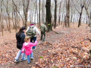 Dillon State Park is a 2,285-acre park located in Muskingum County. The parks has 9.6 miles of multi–use trails, 1.25 miles of trails used exclusively for hiking, 15 miles of bridle trails, and 12 miles mountain bike trails. For those in the Columbus area, the park is about an hour to an hour-and-a-half drive east of the capitol. We had never been to Dillon State Park before, so when we heard the park was hosting its first annual winter hike on January 9th, we decided to participate.
We
Dillon State Park is a 2,285-acre park located in Muskingum County. The parks has 9.6 miles of multi–use trails, 1.25 miles of trails used exclusively for hiking, 15 miles of bridle trails, and 12 miles mountain bike trails. For those in the Columbus area, the park is about an hour to an hour-and-a-half drive east of the capitol. We had never been to Dillon State Park before, so when we heard the park was hosting its first annual winter hike on January 9th, we decided to participate.
We 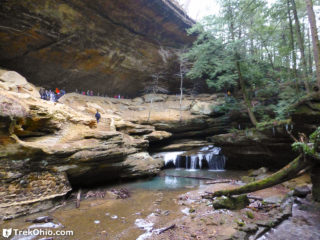 We participated in the 51st Annual Hocking Hills Winter Hike on Saturday. This was our seventh time participating in this winter hike that runs from Old Man's Cave to Rose Lake, Cedar Falls, and ends at Ash Cave for a total distance of 6.5 miles. A bus returns participants to the starting point.
The weather for the hike, like most of this winter, was warmer than usual. There were some small patches of snow here and there, and small icicles. But the temperature was above freezing and
We participated in the 51st Annual Hocking Hills Winter Hike on Saturday. This was our seventh time participating in this winter hike that runs from Old Man's Cave to Rose Lake, Cedar Falls, and ends at Ash Cave for a total distance of 6.5 miles. A bus returns participants to the starting point.
The weather for the hike, like most of this winter, was warmer than usual. There were some small patches of snow here and there, and small icicles. But the temperature was above freezing and 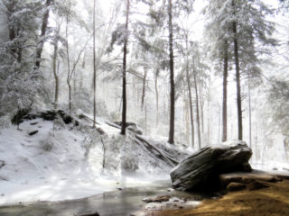 It's time once again for our annual highlights article, so without further ado, the highlights of TrekOhio 2015:
Favorite Photo
Deb: I took the photo below while hiking in the Hocking Hills at Winter’s End.
Bob: My favorite photo for the year was a picture of Deb in front of Horseshoe Falls at Caesar Creek State Park.
Best Hike of the Year
Deb: My favorite hike was Canby's Mountain Lover Trail and Keyhole Arch at Fort Hill. Passing through the keyhole was a great way
It's time once again for our annual highlights article, so without further ado, the highlights of TrekOhio 2015:
Favorite Photo
Deb: I took the photo below while hiking in the Hocking Hills at Winter’s End.
Bob: My favorite photo for the year was a picture of Deb in front of Horseshoe Falls at Caesar Creek State Park.
Best Hike of the Year
Deb: My favorite hike was Canby's Mountain Lover Trail and Keyhole Arch at Fort Hill. Passing through the keyhole was a great way