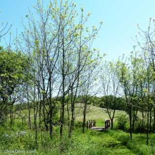
 Knox woods State Nature Preserve is a small, 30 acre woodland with two loop trails. However there are several connector trails to the adjoining Knox County park, Wolf Run Regional Park. Wolf Run is a 288 acre park with diverse habitats (woods, meadows, wetlands) and many facilities for guests. Besides having an enclosed dog park, guests are also allowed to take their leashed dogs on the trails at Wolf Run. Because the park and preserve are next to each other, you can go on a great hike that takes Read more ➜
 Knox Woods State Nature Preserve and Wolf Run Regional Park
Knox woods State Nature Preserve is a small, 30 acre woodland with two loop trails. However there are several connector trails to the adjoining Knox County park, Wolf Run Regional Park. Wolf Run is a 288 acre park with diverse habitats (woods, meadows, wetlands) and many facilities for guests. Besides having an enclosed dog park, guests are also allowed to take their leashed dogs on the trails at Wolf Run. Because the park and preserve are next to each other, you can go on a great hike that takes Read more ➜ 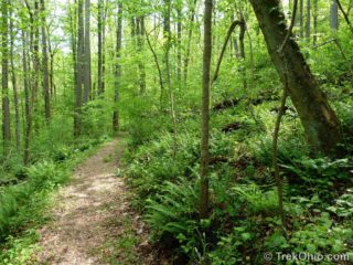 Wahkeena Nature Preserve is a hidden gem located in the SE corner of Fairfield County. The preserve lies just beyond the farthest point of glacial advance at the peak of the ice age. The word, "Wahkeena" is an Indian word meaning, "most beautiful." Given the variety of flowering shrubs and plants (including eight varieties of native orchids), this seems a very fitting name. You will see a brown sign for Wahkeena on US 33 as you head into the Hocking Hills. Wahkeena is well worth a detour.
As
Wahkeena Nature Preserve is a hidden gem located in the SE corner of Fairfield County. The preserve lies just beyond the farthest point of glacial advance at the peak of the ice age. The word, "Wahkeena" is an Indian word meaning, "most beautiful." Given the variety of flowering shrubs and plants (including eight varieties of native orchids), this seems a very fitting name. You will see a brown sign for Wahkeena on US 33 as you head into the Hocking Hills. Wahkeena is well worth a detour.
As  Overview
The Newark Earthworks were constructed about 2000 years ago by the prehistoric, Hopewell people. These are the largest, geometric earthworks in the world. To give you a better sense of the size and shape of these structures, it's best to look at an aerial view. Since I can't take aerial photos myself, I photographed some of the interpretive signs near the earthworks.
The plaque below shows the layout of the Newark Earthworks which occupy four square miles (10.6 square kilometers).
I
Overview
The Newark Earthworks were constructed about 2000 years ago by the prehistoric, Hopewell people. These are the largest, geometric earthworks in the world. To give you a better sense of the size and shape of these structures, it's best to look at an aerial view. Since I can't take aerial photos myself, I photographed some of the interpretive signs near the earthworks.
The plaque below shows the layout of the Newark Earthworks which occupy four square miles (10.6 square kilometers).
I 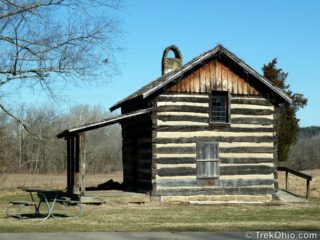 There are three different trail groupings at Blackhand Gorge State Nature Preserve, but for the longest time we only knew of the main parking lot and the trail head that leads off from there. So at the end of this post there's a map and directions showing the location of them all. The icon used to locate the feature on the map is described in parentheses after each heading.
Blackhand Trail, Quarry Rim Trail & Chestnut Trail(Cabin Icon)
There is an old log cabin at the main parking lot across
There are three different trail groupings at Blackhand Gorge State Nature Preserve, but for the longest time we only knew of the main parking lot and the trail head that leads off from there. So at the end of this post there's a map and directions showing the location of them all. The icon used to locate the feature on the map is described in parentheses after each heading.
Blackhand Trail, Quarry Rim Trail & Chestnut Trail(Cabin Icon)
There is an old log cabin at the main parking lot across 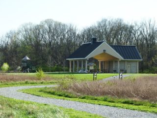 Gallant Woods Preserve is part of Delaware County's Preservation Parks system. In contrast to many of the parks that we have discussed which are tourist attractions in their own right, Gallant Woods is more of a local community resource. It consists of 231 acres of mixed habitat including old growth woods, a wetlands woods, a meadow that's being converted into prairie, and glacial moraine. There's now 1.8 miles of developed trail with more trails planned for the future. The existing trails are all
 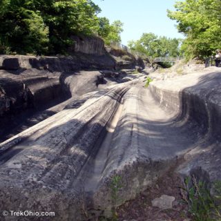 The glacial grooves on Kelley's Island are a designated National Natural Landmark. They were formed during the last Ice Age about 18,000 years ago, and they are the world's largest, known glacial striations. Typically glacial striations are formed when boulders and gravel are dragged across the bedrock under the immense weight of a glacier. Geologists rely on these natural features to determine the direction in which the now-melted ice once flowed. However according to the Ohio Department of Natural
 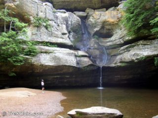 Cedar Falls is a scenic waterfall situated on the trail halfway between Old Man's Cave and Ash Cave. The falls was named by early settlers after the nearby cedar trees, of which there are none. The settlers misidentified the native hemlock trees as cedars.
Cedar Falls can be reached by car on SR 374, just a short drives from either Old Man's Cave or Ash Cave. Amenities include several parking lots, picnic shelters, rest rooms, and drinking water. Although there are several hiking
Cedar Falls is a scenic waterfall situated on the trail halfway between Old Man's Cave and Ash Cave. The falls was named by early settlers after the nearby cedar trees, of which there are none. The settlers misidentified the native hemlock trees as cedars.
Cedar Falls can be reached by car on SR 374, just a short drives from either Old Man's Cave or Ash Cave. Amenities include several parking lots, picnic shelters, rest rooms, and drinking water. Although there are several hiking  Clear Creek Metro Park is part of the Columbus / Franklin Metro Park system, but is located an hours drive from Columbus in the Hocking Hills region.
The entrance to the park is off of route 33. You'll pass a cliff, a large slump block, and a log cabin and reach a parking area in a valley containing the Clear Creek that gave its name to the park. Numerous hiking trails are available in the combined 5,260 acre metro park and the adjacent 4,729 Clear Creek State Nature Preserve. Amenities
Clear Creek Metro Park is part of the Columbus / Franklin Metro Park system, but is located an hours drive from Columbus in the Hocking Hills region.
The entrance to the park is off of route 33. You'll pass a cliff, a large slump block, and a log cabin and reach a parking area in a valley containing the Clear Creek that gave its name to the park. Numerous hiking trails are available in the combined 5,260 acre metro park and the adjacent 4,729 Clear Creek State Nature Preserve. Amenities 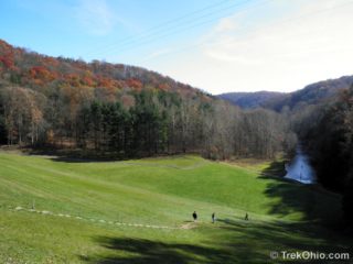 Mohican State Park is one of my favorite places for hiking. The park contains a scenic gorge with the Clear Fork branch of the Mohican River flowing through it. The park is 1,120 acres with the 4,795 acre Mohican Memorial State Forest adjacent to it.
Recreational opportunities abound with several campsites, hiking trails, horseback trails, fly fishing, and boating all available. If that's not enough, nearby there are canoe liveries, the 18.6 mile Butler to Mansfield bike trail, and the
Mohican State Park is one of my favorite places for hiking. The park contains a scenic gorge with the Clear Fork branch of the Mohican River flowing through it. The park is 1,120 acres with the 4,795 acre Mohican Memorial State Forest adjacent to it.
Recreational opportunities abound with several campsites, hiking trails, horseback trails, fly fishing, and boating all available. If that's not enough, nearby there are canoe liveries, the 18.6 mile Butler to Mansfield bike trail, and the 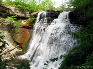 Brandywine Falls is in the Cuyahoga Valley National Park. The falls is named after the village of Brandywine that no longer exists.
The village of Brandywine boomed in the early 1800s because of the waterpower which the falls provided. Here's a vintage photo of the mill associated with the falls.
As transportation technology advanced, first with the Erie Canal, then later with railways, the village of Brandywine was bypassed and their economy gradually deteriorated.
Brandywine Falls is in the Cuyahoga Valley National Park. The falls is named after the village of Brandywine that no longer exists.
The village of Brandywine boomed in the early 1800s because of the waterpower which the falls provided. Here's a vintage photo of the mill associated with the falls.
As transportation technology advanced, first with the Erie Canal, then later with railways, the village of Brandywine was bypassed and their economy gradually deteriorated.