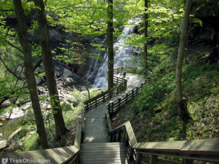
 Just prior to our birding trip to Magee Marsh in May, we visited two waterfalls in the Cuyahoga Valley National Park. We stopped at Brandywine Falls - one of the finest waterfalls in the state of Ohio.
Brandywine Falls
The falls is located on Brandywine Creek where it flows over a 65-foot (19.8m) sandstone and shale cliff. For information on the falls history, facilities, and travel directions, please see our prior article.
Blue Hen Falls
After a quick stop at Read more ➜
Just prior to our birding trip to Magee Marsh in May, we visited two waterfalls in the Cuyahoga Valley National Park. We stopped at Brandywine Falls - one of the finest waterfalls in the state of Ohio.
Brandywine Falls
The falls is located on Brandywine Creek where it flows over a 65-foot (19.8m) sandstone and shale cliff. For information on the falls history, facilities, and travel directions, please see our prior article.
Blue Hen Falls
After a quick stop at Read more ➜ Cuyahoga Valley National Park: Brandywine and Blue Hen Falls
Just prior to our birding trip to Magee Marsh in May, we visited two waterfalls in the Cuyahoga Valley National Park. We stopped at Brandywine Falls - one of the finest waterfalls in the state of Ohio.
Brandywine Falls
The falls is located on Brandywine Creek where it flows over a 65-foot (19.8m) sandstone and shale cliff. For information on the falls history, facilities, and travel directions, please see our prior article.
Blue Hen Falls
After a quick stop at Read more ➜ 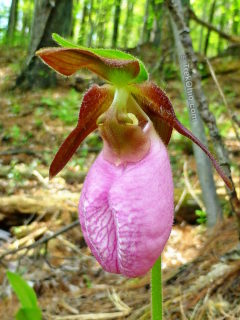 This is a collection of some of my favorite wildflower photos taken in April and May of this year. If you'd like to see a larger version of any flower, just click on its photo.
The above photo was taken at the Wahkeena Nature Preserve. The staff there make it really easy to locate their most picturesque wildflowers. We were greeted by the in-house naturalist, Tom Shisler. He actually gave us a map of the grounds with the locations of the orchids identified by pink marks on the map.
This is a collection of some of my favorite wildflower photos taken in April and May of this year. If you'd like to see a larger version of any flower, just click on its photo.
The above photo was taken at the Wahkeena Nature Preserve. The staff there make it really easy to locate their most picturesque wildflowers. We were greeted by the in-house naturalist, Tom Shisler. He actually gave us a map of the grounds with the locations of the orchids identified by pink marks on the map. 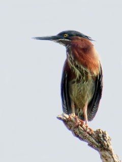 Beaver Marsh is located in Cuyahoga Valley National Park near the Cuyahoga River. Years ago it used to be a junkyard with a small stream flowing through it. A local group cleaned up the junkyard in the mid '80's and then some beavers dammed the stream creating the marsh.
The marsh is on a bike / hike towpath through Cuyahoga Valley National Park that extends 110 miles from Cleveland to Akron and beyond. At the marsh, the gravel towpath changes to a boardwalk with small observation
Beaver Marsh is located in Cuyahoga Valley National Park near the Cuyahoga River. Years ago it used to be a junkyard with a small stream flowing through it. A local group cleaned up the junkyard in the mid '80's and then some beavers dammed the stream creating the marsh.
The marsh is on a bike / hike towpath through Cuyahoga Valley National Park that extends 110 miles from Cleveland to Akron and beyond. At the marsh, the gravel towpath changes to a boardwalk with small observation 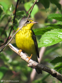 Last week we went to Magee Marsh to check out the action at the Biggest Week in American Birding. This was the second time we made an appearance (the first time is described here). This event is set up to celebrate and observe the migration of warblers in their colorful breeding plumage. Many species are on their way north, but their trip is delayed by Lake Erie. Before these small birds attempt to fly over the lake, they stop on Lake Erie's southern shore to fatten up on bugs, so they'll have the
 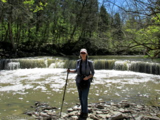 In April we drove to Caesar Creek State Park to visit a new pedestrian suspension bridge and two waterfalls. Our hikes consisted of two segments on the southern portion of the Perimeter Loop Trail. The yellow-blazed Perimeter Loop Trail is an 11.5 mile loop trail on either side of Caesar Creek Lake. The northern and southern routes are connected by a bridge on one end and Caesar Creek Dam on the other.
Our first hike started at the Flat Fork Ridge Recreation Area located on Clarksville
In April we drove to Caesar Creek State Park to visit a new pedestrian suspension bridge and two waterfalls. Our hikes consisted of two segments on the southern portion of the Perimeter Loop Trail. The yellow-blazed Perimeter Loop Trail is an 11.5 mile loop trail on either side of Caesar Creek Lake. The northern and southern routes are connected by a bridge on one end and Caesar Creek Dam on the other.
Our first hike started at the Flat Fork Ridge Recreation Area located on Clarksville 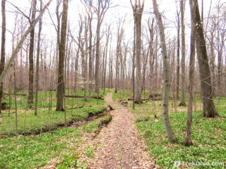 Crall Woods is a 97-acre woodland that's one of two tracts of land making up Pine Hill Park in Ashland County. It was named as a National Natural Landmark by the National Park Service in 1974. According to a sign in the park's kiosk, there are three nature trails at Crall Wood with a total length of 2.45 miles. However, we saw two unlisted trails (one under construction and the other complete) that were not listed on the kiosk. All the trails were wide and well-maintained.
In a recent comment
Crall Woods is a 97-acre woodland that's one of two tracts of land making up Pine Hill Park in Ashland County. It was named as a National Natural Landmark by the National Park Service in 1974. According to a sign in the park's kiosk, there are three nature trails at Crall Wood with a total length of 2.45 miles. However, we saw two unlisted trails (one under construction and the other complete) that were not listed on the kiosk. All the trails were wide and well-maintained.
In a recent comment 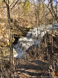 This past weekend we visited the Fallsville Wildlife Area in Highland County. The wildlife area contains a stream valley with a large waterfall. After recent rains it was running quite well. The wildlife area and the falls are named after the town of Fallsville, OH. The town is long gone, but the name lives on.
We parked off of Careytown Rd. about a 1/4 mile south of the local ODNR Wildlife Area Headquarters. A small dirt road is shown on maps as Township Road 432. The road widens
This past weekend we visited the Fallsville Wildlife Area in Highland County. The wildlife area contains a stream valley with a large waterfall. After recent rains it was running quite well. The wildlife area and the falls are named after the town of Fallsville, OH. The town is long gone, but the name lives on.
We parked off of Careytown Rd. about a 1/4 mile south of the local ODNR Wildlife Area Headquarters. A small dirt road is shown on maps as Township Road 432. The road widens 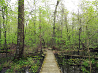 Fowler Woods is a 187-acre, state nature preserve located in Richland Coundy in northeast Ohio. Originally the preserve featured a handicap-accessible, 1 ¼-mile boardwalk, but in 2014 much of the boardwalk was closed to the public due to safety concerns. The boardwalk passes through mature forest, buttonbush swamps, and an area that was once farmland, but is now reverting to forest. Sadly the lower, wetland region within this area that is now barred to the public. The preserve used to be one
 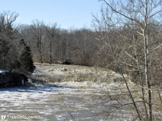 In February 2014 we visited Greenville Falls State Scenic River Area, north of Dayton. It is a 92-acre park, owned by the Ohio Department of Natural Resources but managed by the Miami County Part District. The falls consist of a scenic, 20-foot cascade in Greenville Creek. The park also features ruins of historical interest, nearly a mile of trail, access to fishing spots, a limestone natural arch, picnic areas, kiosks, interpretive signs, and a port-a-potty.
Richard M. Albery, Sr.
In February 2014 we visited Greenville Falls State Scenic River Area, north of Dayton. It is a 92-acre park, owned by the Ohio Department of Natural Resources but managed by the Miami County Part District. The falls consist of a scenic, 20-foot cascade in Greenville Creek. The park also features ruins of historical interest, nearly a mile of trail, access to fishing spots, a limestone natural arch, picnic areas, kiosks, interpretive signs, and a port-a-potty.
Richard M. Albery, Sr.